Loading
  • 21 Aug, 2019

  • By, Wikipedia

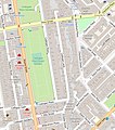
File:Cadogan Lane Vicinity Map.jpg

The ODbL does not require any particular license for maps produced from ODbL data. Prior to 1 August 2020, map tiles produced by the OpenStreetMap Foundation were licensed under the CC-BY-SA-2.0 license. Maps produced by other people may be subject to other licences.
Captions

Cadogan Lane vicinity map

Items portrayed in this file

depicts

image/jpeg

cbb4770df8336bd1d432fbf5d62b79ba87257955

396,271 byte

646 pixel

573 pixel

File history

Click on a date/time to view the file as it appeared at that time.

Date/TimeThumbnailDimensionsUserComment
current22:03, 22 September 2021Thumbnail for version as of 22:03, 22 September 2021573 × 646 (387 KB)PhilafrenzyUploaded a work by Open Street Map contributors from https://www.openstreetmap.org/#map=17/51.49597/-0.15768 with UploadWizard

The following page uses this file: