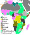
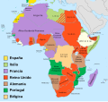
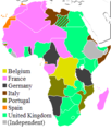
File:Colonial Africa 1913 Map.svg
Own work (Original text: Own work ;)
Author
Eric Gaba (Sting - fr:Sting)
Permission
(Reusing this file)
Other versions
SVG development
- Background map : Africa map political-fr.svg (this revision) (modified) created by myself ;
- Reference maps :
- Map by John Bartholomew & Co. visible on Britishempire.co.uk ;
- Map from Hammond's Atlas of the Modern World, 1917 ;
- Map from WHKMLA Historical Atlas ;
- Map from the Texas Education Agency.
- Map by John Bartholomew & Co. visible on Britishempire.co.uk ;
(Reusing this file)
| Attribution and Share-Alike required |
|---|
| Any use of this map can be made as long as you credit me (Eric Gaba – Wikimedia Commons user: Sting) as the author and distribute the copies and derivative works under the same license(s) that the one(s) stated below. A message with a reply address would also be greatly appreciated. |
[]
- 1800
-
 English

- 1870
-
 English

- 1900
-
 English

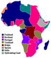
- between 1912 and 1914
-
 español
 -
 Deutsch
 -
 asturianu
 -
 閩南語 / Bân-lâm-gú
 -
 čeština
 -
 dansk
dansk -
 Deutsch
 -
 Deutsch
 -
Deutsch
-
 English
 -
 English
 -
 English
 -
 English
 -
 English
 -
 English
 -
 español
 -
 español
 -
 español
 -
 español
 -
 euskara
 -
 euskara
 -
 føroyskt
 -
 Kiswahili
 -
 norsk
norsk -
 polski
 -
 polski
 -
 svenska
 -
 български
 -
 српски (ћирилица)
 -
 српски (ћирилица)
 -
 Ελληνικά
 -
 中文
中文 -
 中文
中文
.svg)

_ast.svg)


-es.svg)
_mapa.png)

_eu.svg)


.svg)

.jpg)


-sr.png)


- 1923
-
 English

- 1935
-
 English

- 1939
-
 español
 -
 English
 -

.svg)


- 1947
-
 español
 -
 polski
.svg)

Licensing
Eric Gaba, the copyright holder of this work, hereby publishes it under the following licenses:

|
Permission is granted to copy, distribute and/or modify this document under the terms of the GNU Free Documentation License, Version 1.2 or any later version published by the Free Software Foundation; with no Invariant Sections, no Front-Cover Texts, and no Back-Cover Texts. A copy of the license is included in the section entitled GNU Free Documentation License. |
| This file is licensed under the Creative Commons Attribution-Share Alike 3.0 Unported license. | ||
| Attribution: Eric Gaba – Wikimedia Commons user: Sting | ||
| ||
| This licensing tag was added to this file as part of the GFDL licensing update. |
This file is licensed under the Creative Commons Attribution-Share Alike 2.5 Generic license.
Attribution: Eric Gaba – Wikimedia Commons user: Sting
- You are free:
- to share – to copy, distribute and transmit the work
- to remix – to adapt the work
- Under the following conditions:
- attribution – You must give appropriate credit, provide a link to the license, and indicate if changes were made. You may do so in any reasonable manner, but not in any way that suggests the licensor endorses you or your use.
- share alike – If you remix, transform, or build upon the material, you must distribute your contributions under the same or compatible license as the original.
You may select the license of your choice.


