Loading
  • 21 Aug, 2019

  • By, Wikipedia

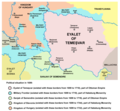
File:Eyalet Of Temesvar1699.png

self made map by user:PANONIAN

Public domain I, the copyright holder of this work, release this work into the public domain. This applies worldwide.
In some countries this may not be legally possible; if so:
I grant anyone the right to use this work for any purpose, without any conditions, unless such conditions are required by law.

Captions

Add a one-line explanation of what this file represents

Items portrayed in this file

depicts

20 March 2009

image/png

File history

Click on a date/time to view the file as it appeared at that time.

Date/TimeThumbnailDimensionsUserComment
current21:11, 14 September 2013Thumbnail for version as of 21:11, 14 September 20131,010 × 984 (113 KB)WikiEditor2004aesthetics
20:20, 5 September 2013Thumbnail for version as of 20:20, 5 September 20131,010 × 984 (117 KB)WikiEditor2004corrections
16:59, 30 September 2011Thumbnail for version as of 16:59, 30 September 20111,015 × 984 (117 KB)WikiEditor2004correction
12:42, 29 September 2011Thumbnail for version as of 12:42, 29 September 20111,015 × 984 (117 KB)WikiEditor2004some corrections
21:04, 22 March 2009Thumbnail for version as of 21:04, 22 March 20091,015 × 984 (120 KB)WikiEditor2004
12:02, 20 March 2009Thumbnail for version as of 12:02, 20 March 20091,015 × 936 (121 KB)WikiEditor2004
02:15, 20 March 2009Thumbnail for version as of 02:15, 20 March 20091,015 × 894 (111 KB)WikiEditor2004map of the Eyalet of Temesvar and Military Frontier in 1699 (self made) {{PD-self}} Category:Maps of the history of Romania Category:Maps of the history of Serbia Category:Maps of the history of Vojvodina

Global file usage

The following other wikis use this file: