Loading
  • 21 Aug, 2019

  • By, Wikipedia

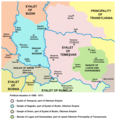
File:Ottoman Vojvodina01.png

self made map by user:PANONIAN

Public domain I, the copyright holder of this work, release this work into the public domain. This applies worldwide.
In some countries this may not be legally possible; if so:
I grant anyone the right to use this work for any purpose, without any conditions, unless such conditions are required by law.

Captions

Add a one-line explanation of what this file represents

Items portrayed in this file

depicts

23 March 2009

image/png

File history

Click on a date/time to view the file as it appeared at that time.

Date/TimeThumbnailDimensionsUserComment
current14:33, 20 April 2015Thumbnail for version as of 14:33, 20 April 2015944 × 978 (107 KB)WikiEditor2004corrections
08:45, 12 October 2013Thumbnail for version as of 08:45, 12 October 2013944 × 978 (107 KB)WikiEditor2004aesthetics
20:58, 14 September 2013Thumbnail for version as of 20:58, 14 September 2013945 × 978 (107 KB)WikiEditor2004aesthetics
19:22, 5 September 2013Thumbnail for version as of 19:22, 5 September 2013945 × 978 (107 KB)WikiEditor2004minor change
14:12, 31 March 2009Thumbnail for version as of 14:12, 31 March 2009947 × 978 (107 KB)WikiEditor2004
22:19, 23 March 2009Thumbnail for version as of 22:19, 23 March 2009947 × 978 (106 KB)WikiEditor2004historic map of the Eyalet of Temeşvar, Sanjak of Sirem, Sanjak of Segedin, and Banate of Lugos and Karansebes (self made) {{PD-self}} Category:Maps of the history of Romania Category:Maps of the history of Serbia [[Category:Maps of the history o

Global file usage

The following other wikis use this file: