File:Possible Definitions Of The Boundary Between Europe And Asia.png
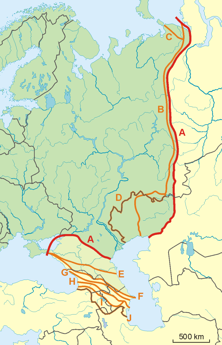
Note that most of these lines are not referenced to any sources proposing them. The red line marked "A" is apparently the "Strahlenberg" definition commononly taught in Soviet-era Russia.
See File:Historical Europe-Asia boundaries 1700 to 1900.png for a map which is actually based on references.
The modern mainstream definition used by the UN (see also this) are marked "B" (Urals and Ural River) and "F" (Caucasus watershed).
Lines C, D, E, G, H, I and J are currently without reference.
Red line - "Strahlenberg" border, allegedly also used by the International Geographical Union [1]
- A: Ural Mountains-Emba River and Kuma Manych Depression (at Rivers Kuma, Manych and lower Don)
Orange lines - other variants of border:
- B: Ural Mountains-Ural River (modern mainstream definition)
- C: Yugorsky Strait Cape–Pay Khoy Mountains–Ural Mountains-Ural River
- D: Ural Mountains-Kazakhstan Border
- E: northern foothills of Caucasus
- F: Lines on the Great Caucasus watershed (modern mainstream definition)
- G: southern foothills of Caucasus
- H: Meso-Caucasus at Rivers Rioni and Kura
- I: Lines on the Lesser Caucasus and Rivers Araks and Kura
- J: former Soviet Union border
Polski: Mapa wariantów przebiegów granicy pomiędzy Europą a Azją
- A: przebieg granicy wg Międzynarodowej Unii Geograficznej: [2] rzeką Don, Obniżeniem Kumsko-Manyckim, doliną Kumy, brzegiem Morza Kaspiskiego, doliną Emby, Mugodżorami, górnym biegiem rzeki Ural, wschodnim podnóżem gór Ural, rzeką Bajdarata do Zatoki Bajdarackiej
linie pomarańczowe - inne warianty przebiegu granicy:
- B: od Morza Kaspijskiego rzeką Ural, następnie grzbietem Uralu (działem wód) i na północy bezpośrednio do Morza Karskiego
- C: od Morza Kaspijskiego rzeką Ural, następnie grzbietem Uralu i grzbietem gór Paj Choj aż do przylądka Jugorskij Szar (odmiana wariantu B)
- D: od Morza Kaspijskiego granicą rosyjsko-kazachską, a następnie górami Ural
- E: wzdłuż północnych podnóży Kaukazu
- F: szczytami Wielkiego Kaukazu, od Półwyspu Apszerońskiego po Cieśninę Kerczeńską
- G: wzdłuż południowych podnóży Kaukazu
- H: obniżeniem tektonicznym między Wielkim i Małym Kaukazem - czyli wzdłuż rzek Rioni i Kura
- I: wzdłuż grzbietu Małego Kaukazu i dalej wzdłuż rzek Araks i Kura
- J: wzdłuż dawnej południowej granicy ZSRR


