File:Zambezi River Delta.jpg
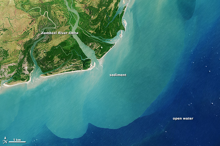
Die Operasionele Landafbeelder aanboord die Landsat 8-satelliet het op 29 Augustus 2013 hierdie beeld van die Zambezidelta in natuurlike kleur verkry. Sandbanke en -versperrings strek oor die monding van die delta heen, en sediment in suspensie word tien kilometer ver die see ingevoer. Die kuswaters kry weens hierdie sanderige uitvloei 'n melkerige blougroen kleur, in teenstelling met die Indiese Oseaan se diepwaters wat 'n donkerblou is.
Die Zambezidelta se kuslyn vorm 'n 230 km-lange front, en die binnelandse vloedvlakte bestaan uit 18 000 vierkante kilometer van moerasse, grasveld en selfs savanne. Die gebied is lank reeds gesog onder bestaansvissers en -boere wat vrugbare grond soek vir gewasse soos suiker, en waters waarin garnale en vis gedy. Buffels, kraanvoëls en ander wildlewe vind ook in hierdie internasionaal erkende vleiland 'n toevlugsoord.
English: Zambezi River Delta drains a watershed that spans eight countries and nearly 1.6 million square kilometers (600,000 square miles). The Zambezi (also Zambeze) is the fourth largest river in Africa, and the largest east-flowing waterway. From headwaters in Zambia, it rolls across 2,574 kilometers (1,599 miles) of the south-central African plateau before pouring water and sediment into the Indian Ocean through a vast delta in Mozambique.
The Operational Land Imager on the Landsat 8 satellite acquired this natural-color image of the Zambezi Delta on August 29, 2013. Sandbars and barrier spits stretch across the mouths of the delta, and suspended sediment extends tens of kilometers out into the sea. The sandy outflow turns the coastal waters to a milky blue-green compared to the deep blue of open water in the Indian Ocean.
The Zambezi Delta includes 230 kilometers of coastline fronting 18,000 square kilometers (7,00 square miles) of swamps, floodplains, and even savannahs (inland). The area has long been prized by subsistence fishermen and farmers, who find fertile ground for crops like sugar and fertile waters for prawns and fish. Buffaloes, cranes, and other wildlife also have found a haven in this internationally recognized wetland.

