Loading
  • 21 Aug, 2019

  • By, Wikipedia

Portal:Oregon

Oregon (/ˈɒrɪɡən, -ɡɒn/ ORR-ih-ghən, -⁠gon) is a state in the Pacific Northwest region of the United States. It is a part of the Western U.S., with the Columbia River delineating much of Oregon's northern boundary with Washington, while the Snake River delineates much of its eastern boundary with Idaho. The 42° north parallel delineates the southern boundary with California and Nevada. The western boundary is formed by the Pacific Ocean.

Oregon has been home to many indigenous nations for thousands of years. The first European traders, explorers, and settlers began exploring what is now Oregon's Pacific coast in the early to mid-16th century. As early as 1564, the Spanish began sending vessels northeast from the Philippines, riding the Kuroshio Current in a sweeping circular route across the northern part of the Pacific. In 1592, Juan de Fuca undertook detailed mapping and studies of ocean currents in the Pacific Northwest, including the Oregon coast as well as the strait now bearing his name. The Lewis and Clark Expedition traversed Oregon in the early 1800s, and the first permanent European settlements in Oregon were established by fur trappers and traders. In 1843, an autonomous government was formed in the Oregon Country, and the Oregon Territory was created in 1848. Oregon became the 33rd state of the U.S. on February 14, 1859.

Today, with 4.2 million people over 98,000 square miles (250,000 km), Oregon is the ninth largest and 27th most populous U.S. state. The capital, Salem, is the third-most populous city in Oregon, with 175,535 residents. Portland, with 652,503, ranks as the 26th among U.S. cities. The Portland metropolitan area, which includes neighboring counties in Washington, is the 25th largest metro area in the nation, with a population of 2,512,859. Oregon is also one of the most geographically diverse states in the U.S., marked by volcanoes, abundant bodies of water, dense evergreen and mixed forests, as well as high deserts and semi-arid shrublands. At 11,249 feet (3,429 m), Mount Hood is the state's highest point. Oregon's only national park, Crater Lake National Park, comprises the caldera surrounding Crater Lake, the deepest lake in the U.S. The state is also home to the single largest organism in the world, Armillaria ostoyae, a fungus that runs beneath 2,200 acres (8.9 km) of the Malheur National Forest. (Full article...)

The watershed of Big Butte Creek
Big Butte Creek is a 12-mile (19 km) long tributary of the Rogue River located in the U.S. state of Oregon. It drains approximately 245 square miles (630 km) of Jackson County. The north fork of the creek begins on Rustler Peak and the south fork's headwaters are near Mount McLoughlin. They meet near Butte Falls, and Big Butte Creek flows generally northwest until it empties into the Rogue River about 1 mile (1.6 km) southwest of Lost Creek Dam. Big Butte Creek's watershed was originally settled over 8,000 years ago by Native Americans. In the Rogue River Wars of the 1850s, most of the Native Americans were either killed or forced onto Indian reservations. The first European American settlers arrived in the 1860s, and the area was quickly developed. The creek was named after Snowy Butte, an early name for Mount McLoughlin. In the late 19th century, the watershed was primarily used for agriculture and logging. Big Butte Springs, located in the watershed, provides clean drinking water to over 115,000 residents of the Rogue Valley. It emits over 26,000,000 US gallons (98,000,000 L) of water per day. Water from Big Butte Creek also is diverted for irrigation in several other places. The water quality of the Big Butte Creek watershed is generally high, and supports several species of trout and salmon. The watershed is also home to over 152 species of birds, 63 species of mammals, 19 species of reptiles, and numerous plants. The Poverty Flats region was designated an Area of Critical Environmental Concern by the Bureau of Land Management in 1995 to protect several rare species of plants.

Selected biography - show another

Hume about 1893
Robert Deniston Hume (October 31, 1845 – November 25, 1908) was a cannery owner, pioneer hatchery operator, politician, author, and self-described "pygmy monopolist" who controlled salmon fishing for 32 years on the lower Rogue River in U.S. state of Oregon. Born in Maine, and reared by foster parents on a farm, Hume moved at age 18 to San Francisco to join a salmon-canning business started by two of his brothers. They later re-located to Astoria on the Columbia River. After the death of his first wife and their two young children, Hume moved again and started anew in Gold Beach, at the mouth of the Rogue. In 1877 Hume bought rights to a Rogue River fishery, then built a cannery and many other structures and acquired all of the tidelands bordering the lower 12 miles (19 km) of the river. He re-married, invested in a small fleet of ships and a salmon hatchery and expanded his business interests to include a store, hotel, newspaper, and many other enterprises in Gold Beach and in the nearby community of Wedderburn, which he founded. Over the years, he became known as the Salmon King of Oregon. Hume often wrote editorials, engaged in litigation, appealed to legislators, and waged political campaigns to protect his business interests. A Republican, he was twice elected to represent Coos and Curry counties in the Oregon House of Representatives. Despite his efforts to maintain a steady fish supply through egg-collecting and fish-rearing, salmon catches on the Rogue, rising in some years and falling in others, generally declined over time.

In this month

<< Previous month Next month >>

More did you know - load new batch

Tiller Ranger Station

Did you know (auto-generated) - load new batch

General images - load new batch

The following are images from various Oregon-related articles on Wikipedia.

Selected image - show another

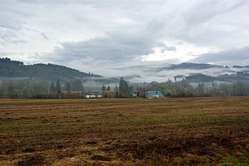
Coast Range, Washington County
Credit: M.O. Stevens

Fog and low clouds in the Northern Oregon Coast Range in winter. The site is near Balm Grove, a community in Washington County.

Selected quote - show another

Peter DeFazio
The University of Oregon has long been known as a renowned research institution. The Brain, Biology and Machine Initiative continues in that distinguished tradition.

Selected panorama - show another

Hawthorne Bridge
Hawthorne Bridge
Credit: Cacophony
The Hawthorne Bridge in Portland, seen from the southeast side of the bridge.

Main topics

Extended content
See also: Good articles relating to Oregon

Good articles

Picture of the day pictures

Subcategories

Category puzzle
Category puzzle
Select [►] to view subcategories

List articles

Culture

Education

Economy

Geography

Government

History

Law

Media

Natural history

Lighthouse of Cape Meares, Oregon

People

Protected areas

Transportation

State facts

State symbols:

American beaver
Western meadowlark
Chinook salmon
Oregon grape
Oregon Swallowtail butterfly
Douglas fir
Metasequoia
Sunstone
Thunderegg

WikiProjects

Things you can do

Extended content
This month's Collaboration of the Month projects: Women's History Month: Create or improve articles for women listed at Oregon Women of Achievement (modern) or Women of the West, Oregon chapter (historical)
Portland, Oregon, in 1898 (Featured picture candidate)

Associated Wikimedia

The following Wikimedia Foundation sister projects provide more on this subject:

More portals

Purge server cache

44°00′N 120°30′W / 44°N 120.5°W / 44; -120.5