Aguas Calientes, Peru
The village of Machupicchu did not exist until the railroad was built, as it was a center for construction workers. It took off after the railroad opened in 1931 and foreign tourists started arriving to visit the Machu Picchu ruins. Enterprising individuals set up businesses serving the tourists, primarily restaurants and small hotels. Those who could afford luxury stayed at the luxury hotel up by the ruins.
Name
The official name comes from Quechua Machu Pikchu from machu old, old person, pikchu pyramid; mountain; or prominence with a broad base that ends in sharp peaks. The addition of "pueblo" comes from the Spanish word for town. It was formerly called Aguas Calientes meaning "hot waters" or "hot springs".
History
Settled by a few farm families in 1901, the settlement was transformed into a busy railway worker's camp called Maquinachayoq (from Quechua makina (a borrowing from Spanish máquina, machine/locomotive/train, -plus the diminutive -cha suffix and -yuq possession suffix, i.e. "(place) with a little train", Makinachayuq) during the construction of the railroad through there in the late 1920s. The town was the central hub for worker lodging and their equipment until the railway was completed in 1931.
Transport
Machupicchu serves as a terminal for the PeruRail and Inca Rail passenger train service from Cusco. Trains serve locals and tourists arriving from Cusco and Ollantaytambo to visit Machu Picchu. Avenue Pachacutec is the main and only thoroughfare of the town, connecting the baths to the town's main square.
Industry
The Central Machupicchu Hydroelectric Plant (Hidroelectrica) is nearby at the Urubamba River. It generates about 90 MW for the regions of Cusco, Puno, and Apurímac . It was first constructed between 1958 and 1965 and expanded between 1981 and 1985. The plant was damaged by a landslide on 28 February 1998 and ceased operations until 13 July 2001.
Climate
| Climate data for Machu Picchu (elevation 2,399 m (7,871 ft), 1991–2020 normals) | |||||||||||||
|---|---|---|---|---|---|---|---|---|---|---|---|---|---|
| Month | Jan | Feb | Mar | Apr | May | Jun | Jul | Aug | Sep | Oct | Nov | Dec | Year |
| Mean daily maximum °C (°F) | 20.6 (69.1) |
20.6 (69.1) |
21.0 (69.8) |
21.5 (70.7) |
21.9 (71.4) |
22.0 (71.6) |
22.1 (71.8) |
23.1 (73.6) |
23.4 (74.1) |
22.8 (73.0) |
22.8 (73.0) |
21.2 (70.2) |
21.9 (71.5) |
| Mean daily minimum °C (°F) | 11.8 (53.2) |
11.9 (53.4) |
11.9 (53.4) |
11.7 (53.1) |
10.8 (51.4) |
10.0 (50.0) |
9.4 (48.9) |
10.0 (50.0) |
11.1 (52.0) |
11.5 (52.7) |
12.0 (53.6) |
12.0 (53.6) |
11.2 (52.1) |
| Average precipitation mm (inches) | 340.7 (13.41) |
324.5 (12.78) |
340.6 (13.41) |
184.1 (7.25) |
73.4 (2.89) |
50.8 (2.00) |
54.2 (2.13) |
60.6 (2.39) |
76.2 (3.00) |
163.0 (6.42) |
172.5 (6.79) |
275.4 (10.84) |
2,116 (83.31) |
| Source: National Meteorology and Hydrology Service of Peru | |||||||||||||
Gallery
-
-
 Train tracks bisect the town
 -
 Machupicchu Village Scene, March 2006
 -
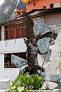 Statue of Inka
 -
 Church Machu Picchu
 -
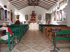 Interior of the church
 -
 Railbus Officials in Aguas Calientes.
 -
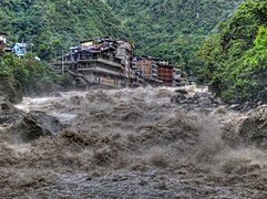
 Rio Aguas Calientes flowing through the town.


,_interior_of_the_church.jpg)

.jpg)
Twin towns
 Haworth, United Kingdom
 Otama village, Fukushima Prefecture, Japan
- Fukushima, Japan
 Petra, Jordan
 Medley, United States
 Tinúm, Mexico
See also
References
- ^ escale.minedu.gob.pe – UGEL map of the Urubamba Province (Cusco Region)
- ^ spij.minjus.gob.pe Archived 27 August 2017 at the Wayback Machine Ley 9396 (Law 9396 1 October 1941) (in Spanish): "... El nuevo distrito que se crea por la presente ley se denominará Machupicchu y tendrá por capital la población de este nombre que se ha formado alrededor de la actual Estación de Machupicchu. ..."
- ^ Teofilo Laime Acopa, Diccionario Bilingüe, Iskay simipi yuyay k'ancha, Quechua – Castellano, Castellano – Quechua (Quechua-Spanish dictionary): machu – adj. y s. m. Viejo. Hombre de mucha edad (Úsase también para animales). – machu – s. m. Anciano. Viejo. pikchu – s. Pirámide. Sólido puntiagudo de varias caras. machu pikchu – s. La gran ciudadela pétrea que fue quizá uno de los más grandes monumentos religiosos del incanato, entre el valle del Cusco y la selva virgen (JAL). || Monumento arqueológico situado en el departamento actual del Cusco, junto al río Urubamba, en una cumbre casi inaccesible (JL).
- ^ Municipalidad distrital de Machupicchu, Plan de desarrollo concertado del Distrito de Machupicchu 2011–2020 (in Spanish), p. 12: "... Machupicchu Pueblo mal llamado Aguas Calientes ..." (meaning "... Machupicchu Village, misnamed Aguas Calientes ...")
- ^ "babylon.com". Archived from the original on 10 June 2015. Retrieved 13 September 2013.
- ^ whc.unesco.org/download.cfm?id_document=100776 Report on the reactive monitoring mission to the historic sanctuary of Machu Picchu (Peru), 22 April to 30 April 2007
- ^ "Aguas Calientes History". Archived from the original on 20 February 2012. Retrieved 23 January 2009.
- ^ [1] Inca Rail]
- ^ (in Spanish) Central Hidroeléctrica Machupicchu Archived 26 June 2007 at the Wayback Machine Empresa de Generación Eléctrica Machupicchu S.A.
- ^ "Normales Climaticás Estándares y Medias 1991-2020". National Meteorology and Hydrology Service of Peru. Archived from the original on 21 August 2023. Retrieved 22 August 2023.
External links
- Aguas-Calientes.com
- Aguas Calientes at cusco-peru.org
 Aguas Calientes travel guide from Wikivoyage
| International | |
|---|---|
| National | |