Ain Mohammed
Etymology
Named after a local well, the first constituent of the village's name, "ain", refers to a natural source of water in Arabic. "Mohammed" was the name of the individual who built the well which supplied water to the village.
History
In 1908, J.G. Lorimer recorded Ain Mohammed in his Gazetteer of the Persian Gulf, giving its location as "2 miles north-east of Zubarah". He makes note of a masonry well, 3 fathoms deep, yielding indifferent water, and a ruined fort.
Based on field work carried out by anthropologists in Qatar in the 1950s, the main tribe in the area of Ain Mohammed were the Al Mujedem branch of the Al Naim tribe.
Archaeologists have concluded that, due to the building materials used and subtle structural differences, the village was originally constructed in three distinct phases.
Archaeology
Rock carvings have been discovered at Ain Mohammed.
Gallery
-
Site of the Ain Mohammed well which the village was named after
-
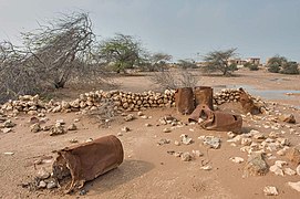
Ruined houses in Ain Mohammed
-
Remains of an oildrum fence for a farm in a depression in Ain Mohammed
-
Old Ain Mohammed Cemetery.
References
- ^ "District Area Map". Ministry of Development Planning and Statistics. Retrieved 20 May 2019.
- ^ "Qatar National Development Strategy 2011–2016" (PDF). Qatar General Secretariat for Development Planning. March 2011. p. 208. Retrieved 6 July 2018.
- ^ "GIS Portal". Ministry of Municipality and Environment. Archived from the original on 18 November 2018. Retrieved 6 July 2018.
- ^ "Reimagining Heritage". Qatar Museums. Retrieved 26 April 2024.
- ^ "'Gazetteer of the Persian Gulf. Vol. II. Geographical and Statistical. J G Lorimer. 1908' [1524] (1639/2084)". Qatar Digital Library. Retrieved 6 July 2018. This article incorporates text from this source, which is in the public domain.
- ^ Ferdinand, Klaus; Carlsberg Foundation's Nomad Research Project (1993). Bedouins of Qatar. Thames & Hudson. p. 51. ISBN 978-0500015735.


