Alamitos Bay
The bay is named for the Spanish word for 'little poplars'.
Geography
Alamitos Bay is protected by both the natural sand spit Peninsula and the Long Beach Breakwater. It is divided from the San Gabriel River and Seal Beach by a pair of jetties. The natural geography has been heavily altered by dredging and landfill subsequent to development.
The bay was severely impacted by the 1939 California tropical storm.
Venues
Alamitos Bay contains Marine Stadium, created for Olympic rowing events.
Water quality
After efforts to clear contaminated sediment and improve circulation, Heal the Bay has re-assessed the water's quality. In a 2020 report, the "Summer Dry Grade" at the 2nd Street Bridge was "B," and at Mother's Beach "A." "Winter Dry Grades" were "C" and "B," respectively. "Wet Weather Grades" were both "F."
The water quality of the bay could be diminished in the future if the pumps of the nearby Alamitos Energy Center are decommissioned. The city is assessing a replacement for these pumps to maintain the bay's water circulation.
Islands
Naples, a collection of three islands, is entirely within Alamitos Bay.
Gallery
-
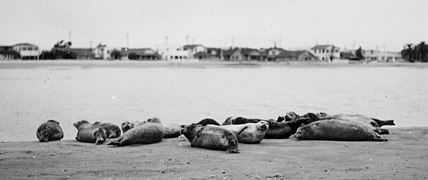
Harbor seals at Alamitos Bay
-
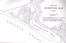
1889 map of Alamitos Bay by Charles Henry Gilbert
-
1960 postcard
See also
- Alamitos Bay Yacht Club
- Peninsula, Long Beach, California
- Anaheim Bay
- Los Cerritos Wetlands
- Colorado Lagoon
References
- ^ Gudde, Erwin; William Bright (2004). California Place Names (Fourth ed.). University of California Press. p. 6. ISBN 0-520-24217-3.
- ^ "Has a Hurricane Ever Made Landfall in California?". KCET. 15 October 2016.
- ^ Maschke, Alena. "Alamitos Bay's water quality at risk once again, unless the city spends millions to fix it • Long Beach Post News". lbpost.com.
- ^ "2019-2020 Beach Report Card" (PDF).
- ^ "Alamitos Bay Water Quality Enhancement". City of Long Beach.


