Alcoutim
Coat of arms

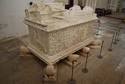
The coat of arms of Alcoutim - a wreath of zambujeiro (wild olive tree) and the slogan Aleo - is derived from the decorative motif of the tomb of Pedro de Menezes, 1st Count of Vila Real, found in the Igreja da Graça in Santarém. 'Aleu' or 'aleo' is an old Portuguese term for a 'gaming stick' (as used in hockey or shuffleboard). It refers to a famous episode concerning Pedro de Menezes from shortly after the Conquest of Ceuta on September 2, 1415 (commemorated on Ceuta Day). Pedro de Menezes was engaged in an outdoor game in the king's presence when a messenger arrived reporting an imminent Moroccan attack on Portuguese-held Ceuta. Menezes is said to have raised his gaming stick (aleo) and told the king that "with that stick alone" he could defend Ceuta from all the power of Morocco. Pedro's descendants were later made Counts of Alcoutim. Similar design can be seen on the coat of arms of Vila Real.
Parishes
Administratively, the municipality is divided into 4 civil parishes (freguesias):
Climate
Alcoutim has a Mediterranean climate (Köppen climate classification Csa) with very hot and dry summers and mild winters. Due to its location in the Guadiana River basin it has a climate that very much resembles that of relatively nearby Seville and Cordoba. With an average July high of around 36 °C (97 °F) it is one of the hottest places in Portugal and Europe during the summer months.
| Climate data for Alcoutim, 1985-2021, altitude: 32 m (105 ft) | |||||||||||||
|---|---|---|---|---|---|---|---|---|---|---|---|---|---|
| Month | Jan | Feb | Mar | Apr | May | Jun | Jul | Aug | Sep | Oct | Nov | Dec | Year |
| Average precipitation mm (inches) | 57.4 (2.26) |
41.8 (1.65) |
36.5 (1.44) |
52.0 (2.05) |
36.5 (1.44) |
11.3 (0.44) |
0.9 (0.04) |
4.0 (0.16) |
23.5 (0.93) |
68.9 (2.71) |
68.9 (2.71) |
90.9 (3.58) |
492.6 (19.41) |
| Source: Portuguese Environment Agency | |||||||||||||
References
- ^ Detail Regional Map, Algarve- Southern Portugal, ISBN 3-8297-6235-6
- ^ Instituto Nacional de Estatística
- ^ "Áreas das freguesias, concelhos, distritos e país". Archived from the original on 2018-11-05. Retrieved 2018-11-05.
- ^ "Alcoutim Castle". castles.nl. Archived from the original on 2007-08-16. Retrieved 25 October 2020.
- ^ "Eu só com este páu, sou capaz de defender Ceuta, de todo o poder dos mouros", as reported in Portugal antigo e moderno, 1878, p. 495.
- ^ Diário da República. "Law nr. 11-A/2013, page 552 8" (PDF) (in Portuguese). Retrieved 16 July 2014.
- ^ "Average Weather in Alcoutim". Weatherspark.com. Retrieved 25 October 2020.
- ^ "Alcoutim (29M/01UG)". APA. Retrieved 23 October 2021.
External links
 Media related to Alcoutim at Wikimedia Commons
- Official website (in Portuguese)
| Municipality of Faro District (Algarve) |
|---|
 |
 |
 |
 |
 |
 |
 |
 |
 |
 |
 |
 |
 |
 |
 |
 |
| Albufeira | Alcoutim | Aljezur | Castro Marim | Faro | Lagoa | Lagos | Loulé | Monchique | Olhão | Portimão | São Brás de Alportel | Silves | Tavira | Vila do Bispo | Vila Real de Santo António |