Ang Thong National Park
Mu Ko Ang Thong is a marine national park in the Gulf of Thailand in Surat Thani Province. It covers 42 islands in a total area of 63,750 rai ~ 102 square kilometres (39 sq mi), of which about 50 square kilometres (19 sq mi) are land and the rest is water. The park was established on 12 November 1980. The northern tip of Ko Phaluai is also part of the marine park. There is a ranger station, bungalows, a shop, and a restaurant at Ao Phi Beach on Ko Wua Talap.
The name "Ang Thong" (Thai: อ่างทอง) means 'bowl of gold'. "Mu Ko" (หมู่เกาะ) simply means 'group of islands'.
Since 2002 the park has been registered as Ramsar site number 1184.
Topography
Mu Ko Ang Thong is a national park located in shallow water near the shore. The average water depth is about 10 m (33 ft).
Islands
| Nr | Island | Capital | Other Cities | Area (km²) | Population |
|---|---|---|---|---|---|
| 1 | Ko Chueak | Ko Chueak | 1.62 | 0 | |
| 2 | Ko Nok Taphao | Ko Nok Taphao | Ao Kruat, Ao Pla, Ao Uttra, | 3.32 | 200 |
| 3 | Ko Phaluai | Ban Ao Sam | Ban Ao Song, Ban Ao Nueng, Ao nathap, Ao Luek | 19.1 | 500 |
| 4 | Ko Raet | Ko Raet | 0.07 | 50 | |
| 5 | Ko Samsao | Ko Samsao | 0.85 | 0 | |
| 6 | Ko Wua Chio | Ko Wua Chio | 0.26 | 2 | |
| 7 | Ko Wua Talap | Ang Thong Station | Ao Phi | 6.06 | 10 |
| 8 | More Islands | 10 | 0 | ||
| Total: | Mu Ko Ang Thong | Ban Ao Sam | Ko Nok Taphao | 40 | 692 |
Gallery
-
 Ang Thong National Park from Ko Wua Talab
 -
 Beach, Ko Mae Ko
 -
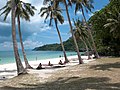
 Beach, Ko Wua Talab
 -
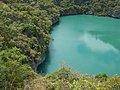 Laguna, Ko Mae Ko
 -
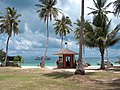 Ranger station
 -
 Beach
Beach -
 Ko Wua Talab


See also
References
- ^ "Mu Koh Ang Thong Marine National Park". Ramsar Sites Information Service. Retrieved 25 April 2018.
- ^ "MU KO ANG THONG NATIONAL PARK". Tourism Authority of Thailand (TAT). Retrieved 2 January 2018.
- ^ "ข้อมูลพื้นที่อุทยานแห่งชาติ ที่ประกาศในราชกิจจานุบกษา 133 แห่ง" [National Park Area Information published in the 133 Government Gazettes]. Department of National Parks, Wildlife and Plant Conservation (in Thai). December 2020. Retrieved 1 November 2022, no 21
{{cite web}}: CS1 maint: postscript (link) - ^ "Mu Ko Ang Thong National Park". Department of National Parks (DNP). Archived from the original on 11 November 2006. Retrieved 2 January 2018.
- ^ "Mu Ko Ang Thong: A highlight of the Gulf of Thailand". Nation Thailand. Retrieved 11 November 2023.
External links
 Media related to Ang Thong National Park at Wikimedia Commons
 Ang Thong National Marine Park travel guide from Wikivoyage
- Mu Ko Ang Thong National Marine Park Tours
This Surat Thani Province location article is a stub. You can help Wikipedia by expanding it. |
This protected areas-related article is a stub. You can help Wikipedia by expanding it. |