Anzac Village, New Mexico
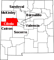
Anzac Village is a census-designated place (CDP) in Cibola County, New Mexico, United States. The population was 54 at the 2010 census.
Geography
Anzac Village is located in northern Cibola County, in the northwest corner of the Acoma Indian Reservation. It is bordered on the north by Anzac Road in the valley of the Rio San Jose; the road connects with Historic U.S. Route 66 to the east and west.
The book place names of New Mexico states that the "town" is small, a railroad siding. The Atchison, Topeka and Santa Fe Railway railroad bestowed the name on this site during WWI in honor of Australia's, and New Zealand's contribution to the war effort.
According to the United States Census Bureau, the CDP has a total area of 0.56 square miles (1.44 km), all land.
Demographics
| Census | Pop. | Note | %± |
|---|---|---|---|
| 2020 | 67 | — | |
| U.S. Decennial Census | |||
References
- ^ "ArcGIS REST Services Directory". United States Census Bureau. Retrieved October 12, 2022.
- ^ U.S. Geological Survey Geographic Names Information System: Anzac Village, New Mexico
- ^ "Census Population API". United States Census Bureau. Retrieved October 12, 2022.
- ^ "Geographic Identifiers: 2010 Demographic Profile Data (G001): Anzac Village CDP, New Mexico". U.S. Census Bureau, American Factfinder. Archived from the original on February 12, 2020. Retrieved October 17, 2014.
- ^ "Census of Population and Housing". Census.gov. Retrieved June 4, 2016.
