Aston Expressway
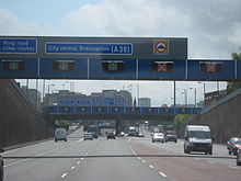
It is extremely unusual as it is the only single carriageway motorway in the United Kingdom and consists of seven lanes with no central reservation, and operates a tidal flow system in an attempt to minimise congestion. Due to the nature of the road, the speed limit is reduced to 50 mph (80 km/h) for most of its length with a very short length of 30 mph (48 km/h), though there are no permanent speed cameras as of 2010.
When construction work of the motorway began in the late 1960s, many late 19th-century and early 20th-century houses in the Aston area had to be demolished to make way for the new route.
Route

The A38(M) runs from the A5127 through Gravelly Hill Interchange where the A38 joins and then shortly after traffic from the M6 motorway also joins. It then enters a tidal flow section. The road is on a viaduct as it passes through Aston; this section cuts through the grounds of Aston Hall. The road passes through its first junction after 1 mile (1.6 km). It enters a cutting before reaching the second junction, where the tidal flow ends as does the motorway. The motorway is curved in Aston to avoid an Ansells brewery. The motorway was also crossed by a vinegar pipeline, carrying the condiment from one part of the since-demolished HP Sauce factory to the other.
Dartmouth Circus

The traffic island at Dartmouth Circus was built where Aston Road met with Dartmouth Street, Bracebridge Street and Allesley Street. where the White Hart public house had been sited.
- A4540 Dartmouth Middleway (previously Dartmouth Street) J13
- A38(M) Aston Expressway
- A38 Aston Road
- A5127 Aston Road
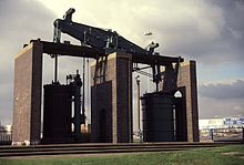
The traffic island at Dartmouth Circus preserves a re-erected Boulton and Watt steam engine (52°29′33″N 1°53′18″W / 52.4925°N 1.8882°W). The engine was built in 1817 and used in Netherton at the ironworks of M W Grazebrook.
Tidal flow
The Expressway was the first road in the United Kingdom to introduce tidal flow to allow better management of traffic. Lane use is controlled by means of electronic overhead signs, with one lane always closed to create a buffer between the two directions of travel – there is no central reservation. During the morning rush, four of the seven lanes are allocated to traffic heading into the city and two to traffic heading out of it. In the evening, this pattern is reversed. At all other times, the road runs with three lanes in each direction.
Motorcycles are banned from the red-surfaced central lane, which contains a drainage channel, regardless of how it is being used. This follows a fatal accident which occurred when one of the drainage covers came loose.
Junctions
This article contains a bulleted list or table of intersections which should be presented in a properly formatted junction table. (December 2021) |
| A38(M) motorway | ||
| Northbound exits | Junction | Southbound exits |
| Road continues to Erdington as A5127 | M6 J6 Gravelly Hill (Gravelly Hill Interchange) |
Start of motorway |
| Lichfield A38 | No exit | |
| London (M1), The MIDLANDS (M42,(M40)), Coventry The NORTH WEST, The SOUTH WEST (M5), Wolverhampton M6 Aston A5127 |
No exit | |
| No exit | Park Circus (52°30′08″N 1°53′02″W / 52.5021°N 1.8839°W) |
Aston B4132 |
| Start of motorway | Dartmouth Circus (52°29′32″N 1°53′19″W / 52.4923°N 1.8887°W) |
Handsworth, Ladywood, Aston, Small Heath A4540 (Birmingham Inner Ring Road) |
| Handsworth, Ladywood, Aston, Small Heath A4540 (Birmingham Inner Ring Road) |
Road continues as A38 to Birmingham City Centre | |
See also
References
- ^ The Motorway Archive A38(M) – Dates Archived 11 March 2007 at the Wayback Machine
- ^ "Google Maps".
- ^ The Motorway Archive – A38(M) Archived 11 March 2007 at the Wayback Machine
- ^ "View map: Warwickshire XIV.NW (Includes: Birmingham.) - Ordnance Survey Six-inch England and Wales, 1842-1952".
- ^ closedpubs.co.uk: White Hart
- ^ CBRD Motorway Database – A38(M)
