Bangkok Yai District
History
The district is named after Khlong Bangkok Yai (คลองบางกอกใหญ่, also called Khlong Bang Luang, คลองบางหลวง) which was actually part of Chao Phraya River until a canal dug in 1522 during the Ayutthaya period altered the flow of the river such that the canal became the main river and the section of original river became present-day Khlong Bangkok Yai. Bangkok Yai, or more precisely, the Wat Arun Sub-district, was also the site of Thon Buri when the capital was set up here from 1767-1782.
Originally called Amphoe Hongsaram (อำเภอหงสาราม) when the district was set up in 1915, it was renamed "Amphoe Bangkok Yai" in 1916, demoted to a king amphoe of amphoe Bang Yi Khan (อำเภอบางยี่ขัน) in 1938, promoted back to amphoe in 1958, and finally changed to a khet in an administrative reform in 1972.
Administration
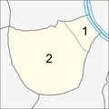
The district is sub-divided into two sub-districts (khwaeng).
| No. | Name | Thai | Area (km) |
Map |
|---|---|---|---|---|
1. |
Wat Arun | วัดอรุณ | 0.834 |

|
2. |
Wat Tha Phra | วัดท่าพระ | 5.346
| |
| Total | 6.180
| |||
Places
Temples


- Wat Arun
- Wat Hong Rattanaram
- Wat Khruea Wan
- Wat Molilokkayaram
- Wat Ratchasittharam
- Wat Nak Klang
- Wat Tha Phra
- Wat Chao Mun
- Wat Diduat
- Wat Pradu Chimphli
- Wat Pradu Nai Songtham
- Wat Sangkrachai
- Wat Mai Phiren
Historic sites
Education
- Taweethapisek School
- Ratchadamnoen Commercial School
- Wiboon Business Administration College
- Siam Technological College
- Sesawech Vidhaya School
- Ritthinarongron School
- Wat Pradu Nai Songtham School
- Bangkok Commercial School
- Saiprasit Business Administration Technological
- Saiprasit School
- Prasart Wittaya Anuchon School
Government offices
- Royal Thai Navy Convention Center
- The Kingdom of Lesotho Consulate
- Bangkokyai Police Station
- Tha Phra Police Station
Transportation
- Tha Phra Intersection
- Tha Phra MRT station
- Chao Phraya River
- Khlong Bangkok Yai
- Khlong Mon
- Phanitchayakan Thon Buri Junction
- Itsaraphap MRT station
Main roads
References
- ^ "Population and House Report for Year 2017". Department of Provincial Administration, Ministry of Internal Affairs. Retrieved 1 April 2018. (Search page)
- ^ "Canal in Thailand (in Thai)". Archived from the original on 22 June 2018. Retrieved 29 July 2016.
- ^ BMA Local Museum - Bangkok Yai (in Thai) Archived 2016-08-10 at the Wayback Machine, The BMA (Bangkok Metropolitan Administration) Local Museum
- ^ History of Bangkok Yai (in Thai) Archived 2016-06-11 at the Wayback Machine, Bangkok Yai District Office
External links
- Bangkok Yai district office (Thai only)
