Bankati, Paschim Bardhaman
Geography

3miles
Projects
Limited
Steels
Plant
Steel
Plant
Barrage
Islam Airport
Area Office
Urbanisation
According to the 2011 census, 79.22% of the population of the Durgapur subdivision was urban and 20.78% was rural. The Durgapur subdivision has 1 municipal corporation at Durgapur and 38 (+1 partly) census towns (partly presented in the map alongside; all places marked on the map are linked in the full-screen map).
Location
Bankati is located at 23°36′00″N 87°29′19″E / 23.6001°N 87.4886°E.
Demographics
According to the 2011 Census of India, Bankati had a toal population of 1,255 of which 650 (52%) were males and 605 (48%) were females. Population in the age range 0–6 years was 125. The total number of literate persons in Bankati was 880 (71.50% of the population over 6 years).
*For language details see Kanksa (community development block)#Language and religion
Education
Eklabya Model School (residential) is a Hindi-medium coeducational institution established in 2002. It has facilities forteaching from class VI to class XII. The school has a library with 81 books and a playground.
Ajodhya High School is a Bengali-medium coeducational school established in 1957. It has facilities for teaching from class V to class XII.
Culture
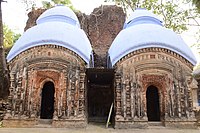
There is a 15 feet high bell metal (pital) chariot at Bankati, built in the 19th century. Designed in the style of a pancharatna temple it has carvings on its body. Bankati has two Shiva temples - Gopeswar Shiva Temple built in 1155 and Pancha Ratna Shiva temple built in 1782.
David J. McCutchion mentions a Shiva Temple at Bankati built in 1832. It is described as a standard type pancharatna temple with bridged rekha turrets and single entrance and terracotta decoration.
Gallery
-
Gopaleswar (possibly Gopeswar) Shiva Temple at Bankati
-
Terracota panels in Gopaleswar Shiva Temple at Bankati
-
Atchala temples at Kalitala, Bankati
-
Shiva Temple at Hattala, Bankati
-
Terracota panels in the Shiva Temple at Hattala, Bankati
References
- ^ "District Statistical Handbook 2014 Burdwan". Table 2.2, 2.4(a). Department of Statistics and Programme Implementation, Government of West Bengal. Archived from the original on 21 January 2019. Retrieved 15 September 2018.
- ^ "2011 Census – Primary Census Abstract Data Tables". West Bengal – District-wise. Registrar General and Census Commissioner, India. Retrieved 15 June 2020.
- ^ "Eklabya Model School (Residential)". Schools.org. Retrieved 14 June 2020.
- ^ "Ajodhya High School". Schools.org.in. Retrieved 14 June 2020.
- ^ Chattopadhyay, Akkori, Bardhaman Jelar Itihas O Lok Sanskriti (History and Folk lore of Bardhaman District.), (in Bengali), Vol II, pages 539-540, Radical Impression. ISBN 81-85459-36-3
- ^ McCutchion, David J., Late Mediaeval Temples of Bengal, first published 1972, reprinted 2017, page 48, The Asiatic Society, Kolkata, ISBN 978-93-81574-65-2


