Burraga
History
Aboriginal and early settler history
The area now known as Burraga lies on the traditional lands of the Wiradjuri people. The name Burraga is almost certainly a settler rendering of an Aboriginal language word. Sydney J. Endacott (Australian Aboriginal Words and Place Names and Their Meanings, 1959) states that Burraga means "Bitter Swamp". Burraga is also the name of the cadastral parish on the northern side of Thompson's Creek.
Mining
Copper was discovered around 1877 and was reported on by the inspector of mines in 1878. Mining commenced at the Thompsons Creek copper mine, but was hampered by poor management and under capitalisation, until the mine was purchased in 1879 by Lewis Lloyd, who was known as "the copper king". The mine then became known as Lloyd's Copper Mine. Lloyd built reverberatory smelting furnaces near the mine. By 1900, it had produced over £1,000,000 worth of copper.
In 1899, Lloyd sold his interest in the mine at Burraga to an English company for £100,000, and the mine became the Lloyd Copper Company Mine. Mining and smelting at Burraga had been hindered by the availability of water and fuel for the furnaces; the new owners set about solving these issues. Construction of a concrete dam on Thompson's Creek was completed in 1901 although, due to a drought, the dam did not fill completely with water until 1903. However, the new owners' attempt to change the smelting process, from using reverberatory furnaces to pyritic smelting in a water jacket blast furnace, was a total failure. Although a large sum was invested in the operation, there had been some poor decisions made. By 1908, the mine operations were in jeopardy, due to a scarcity of fuel, and the mine closed in May that year. The only remaining mining going on to support the village was at the nearby Mt David Gold Mine.
The Lloyd mine appears to have reopened around 1912, with another round of capital investment. A narrow-gauge tramway that used two Shay locomotives was constructed around 1912–1913 to bring timber fuel to the smelter. A fire in late 1913 destroyed one of the locomotives. Falling copper prices led to another closure of the mine in July 1914. The entire mine and associated assets were sold, on behalf of creditors, in 1916, for a mere £5,680. The new owners had the mine, now called the Abercrombie Copper Mine, in production again in March 1917, but problems obtaining enough timber for fuel continued to lead to temporary closures. By mid-1918, wartime shipping conditions had made it impossible to export copper, already sold to the British Government, from N.S.W.; the smelter at Burraga closed in August 1918, with the ore being sent instead to Port Kembla, via the railway station at Perthville.
The mine closed down, in January 1919, and equipment from the operation, including the remaining Shay locomotive, was sold off in 1920. A long-awaited branch railway line from Tarana to Burraga, which would have allowed coal to be brought to the smelters or ore to be shipped more economically, was built only as far as Oberon; it opened in November 1923.
Mining continued on and off up until 1961. Studies were being conducted around 2012, looking for worthwhile lodes of copper and gold at the nearby Lucky Draw Gold Mine.
Private town and village of Burraga
The first settlement at Burraga was a private township on the mining lease of the Thompsons Creek copper mine. As the mine expanded, workers settled on the nearby land resulting in the reservation of a site for a village, immediately to the east of the private township, in October 1883. In 1883, the mine employed about 200 men and that the population of Burraga was about 500 persons including 60 children. The village had "the usual businesses", a post office and a public school, which opened in November 1883. Therefore, even before the village had been planned, a significant settlement and population existed in the area.
The new village was surveyed in December 1884 and a formal plan was reserved on 29 October 1887. The reserve for a road (then known as Mine Street) linking the private township to the new village was surveyed in 1886, but actually contained a number of the town's existing buildings; the road reserve was resurveyed in 1900 to overcome that deficiency. The boundary of the mine's land constrained the alignment of Lloyd Street, so that it intersects the other streets of the village at an angle. The existence of the earlier private township explains why some of Burraga's buildings lie to the west, outside the planned village street grid ending at Lloyd Street. Allotments and former streets of the former private township, to the west of Lloyd Street, are still shown on Google Maps.
As there were no other industries to provide employment the fortunes of the village rose and fell in line with those of the copper mine. The population seems to have peaked in the early 1900s, at around 2,000, during the construction of the new plant at the mine site. When the mine closed for the first time, in 1908, the population was still around 1,500. The population had fallen to 747, in 1911, the year before the mine reopened. It then rose again to around 1,400 to 1500, but after the mine closed for a second time in 1914, the population slumped to only 250 by 1916. Just after the final mine closure, in 1919, the population was 1,231. By 1924, the village's population was only 124.
The village had two hotels; the Royal Hotel was destroyed by fire in 1932 and the Burraga Hotel was closed in 1933, and its disused building was also destroyed by fire in 1942.
Burraga had a Union Church, Anglican and Catholic churches. The only surviving church is St Dympna's Catholic church, dating from 1941, which is still in use.
The public school first closed in December 2006, reopened in February 2009, and finally closed in December 2016.
From around 1900 to around 1915, Estonian-born photographer Evan Antoni Johann Lumme (1865-1935) made photographs of Burraga and some of its inhabitants. Some of these photographs are in the collection of the National Library of Australia.
Present day
Little remains of the copper mine's operations today; the single remaining tall brick chimney that dominates the site is a remnant of the failed attempt at pyritic smelting, the Burraga Dam on Thompson's Creek survives as a popular angling venue, and there are remnant shafts and slag heaps at the sites of the mine and smelters. The mine site is viewed as a prospective film location, as is the village.
The village of Burraga is a quiet place now, but still has a community hall, and a village store that is a postal agency. Aside from limited tourism for camping and angling, the economy of the village relies on grazing, nearby softwood forestry plantations, and sawmilling. The War Memorial Obelisk, in the village's War Memorial Park, commemorates the men who went from Burraga to the two world wars. The Burraga Sports and Services Club serves the village and nearby area.
Gallery
-
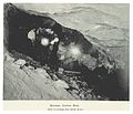 Underground workings of the copper mine (c. 1899)
 -
 Burraga copper mine smelters (c. 1899)
 -
 Burraga copper mine smelters (c. 1899)
 -
 Burraga, mining village c. 1900
_p082_BURRAGA_COPPER_MINE.jpg)
_p079_BURRAGA_COPPER_MINE.jpg)
_p085_BURRAGA_COPPER_MINE,_SMELTING_WORKS.jpg)
References
- ^ Australian Bureau of Statistics (28 June 2022). "Burraga (suburb and locality)". Australian Census 2021 QuickStats. Retrieved 28 June 2022.
- ^ "Burraga". Geographical Names Register (GNR) of NSW. Geographical Names Board of New South Wales. Retrieved 3 August 2014.
- ^ Australian Bureau of Statistics (27 June 2017). "Burraga". 2016 Census QuickStats. Retrieved 21 August 2020.
- ^ Studies, Australian Institute of Aboriginal and Torres Strait Islander (23 July 2021). "Map of Indigenous Australia". aiatsis.gov.au. Retrieved 31 July 2021.
- ^ "Parish of Jeremy, County of Georgiana [cartographic material] : Land District of Blayney". Trove. Retrieved 29 November 2022.
- ^ "Geological Surveyor's Report". The Sydney Morning Herald. Vol. LXXVII, no. 12, 466. New South Wales, Australia. 2 May 1878. p. 5. Retrieved 24 July 2016 – via National Library of Australia.
- ^ Iain, Stuart. "History of Lloyds Copper Mine and the Township of Burraga". Retrieved 23 July 2016.
{{cite journal}}: Cite journal requires|journal=(help) - ^ "The Lloyd Copper Mine at Burraga". Sydney Mail and New South Wales Advertiser. 14 July 1900. p. 86. Retrieved 31 July 2021.
- ^ "Burraga". Lithgow Mercury. 20 April 1900. p. 6. Retrieved 20 August 2020.
- ^ "Lloyd's Copper Mine". The Sydney Morning Herald. 15 December 1906. p. 6. Retrieved 13 September 2020.
- ^ "'Lloyd' Copper Mine". The Sydney Morning Herald. 28 April 1908. p. 11. Retrieved 1 August 2021.
- ^ "Lloyd Mine Closed". National Advocate. 13 May 1908. p. 2. Retrieved 1 August 2021.
- ^ "Depression at Burraga". Leader. 15 January 1909. p. 2. Retrieved 1 August 2021.
- ^ "Mount David Gold Mine (Mount Maude Mine), Georgiana Co., New South Wales, Australia". mindat.org. Retrieved 1 August 2021.
- ^ "Burraga Copper Mine". Leader. 21 June 1912. Retrieved 1 August 2021 – via Trove.
- ^ "Big Fire". The Bathurst Times. New South Wales, Australia. 24 November 1913. p. 2. Retrieved 2 August 2016 – via National Library of Australia.
- ^ "Burraga's Deserted Village". Weekly Times. 25 July 1914. p. 33. Retrieved 1 August 2021.
- ^ "Monetary and Mining". Argus. 18 September 1916. p. 3. Retrieved 1 August 2021.
- ^ "Burraga". Lithgow Mercury. 23 March 1917. p. 3. Retrieved 1 August 2021.
- ^ "Burraga". Lithgow Mercury. 23 May 1917. p. 1. Retrieved 1 August 2021.
- ^ "Burraga". Lithgow Mercury. 27 August 1917. p. 3. Retrieved 1 August 2021.
- ^ "Burraga". National Advocate. 20 August 1917. p. 1. Retrieved 1 August 2021.
- ^ "Burraga Copper Mine". Bathurst Times. 17 August 1918. p. 2. Retrieved 1 August 2021.
- ^ "Perthville Station". nswrail.net. Retrieved 1 August 2021.
- ^ "Close Down at Burraga". Lithgow Mercury. New South Wales, Australia. 29 January 1919. p. 3. Retrieved 2 August 2016 – via National Library of Australia.
- ^ "Advertising". The Sydney Morning Herald. No. 25, 655. New South Wales, Australia. 27 March 1920. p. 3. Retrieved 2 August 2016 – via National Library of Australia.
- ^ "Tarana-Burraga Railway. – Evidence Before the Public Works Committee. At Burraga". Lithgow Mercury. 2 June 1913. Retrieved 12 September 2020 – via Trove.
- ^ "Government Gazette Notices". Government Gazette of the State of New South Wales. 28 September 1923. p. 4252. Retrieved 12 September 2020.
- ^ "Burraga Project". Elysium Resources. Archived from the original on 20 August 2016. Retrieved 26 July 2016.
- ^ Sandra Parker (4 April 2012). "Huge plans for mining at Burraga". Retrieved 26 July 2016.
- ^ "Burraga". nswgovschoolhistory.cese.nsw.gov.au. Retrieved 19 December 2020.
- ^ Osborne, I., 1975. Annual Report Compilation; Berraga Division Bathurst Sheet 1881-1972, 1883
- ^ Plan of the Village of Burruaga (first edition)
- ^ "Map of the village of Burraga and suburban lands [cartographic material] : Parish of Thompson & Jeremy, County of Georgiana, Land District of Blaney, Abercrombie Shire, Eastern Division N.S.W." Trove. Retrieved 29 November 2022.
- ^ "Parish of Thompson, County of Georgiana [cartographic material] : Carcoar Land District, Abercrombie Shire, Eastern Division N.S.W." Trove. Retrieved 29 November 2022.
- ^ "Satellite View: Burraga · New South Wales 2795, Australia". Google Maps. Retrieved 29 November 2022.
- ^ "Burraga · New South Wales 2795, Australia". Google maps. Retrieved 30 November 2022.
- ^ "Projected Railways". Daily Telegraph. Sydney. 11 May 1911. p. 5. Retrieved 1 August 2021.
- ^ "Mining News". Lithgow Mercury. 6 March 1916. p. 2. Retrieved 1 August 2021.
- ^ "Bathurst". Australian Town and Country Journal. 2 April 1919. p. 17. Retrieved 1 August 2021.
- ^ "Licenses Reduction". National Advocate. 10 October 1924. p. 2. Retrieved 1 August 2021.
- ^ Roberts, Mick (27 September 2019). "Burraga's long gone pubs". Time Gents. Retrieved 31 July 2021.
- ^ "BURRAGA METHODIST CHURCH". Lithgow Mercury. 9 December 1904. p. 3. Retrieved 30 November 2022.
- ^ "PRESENTATION AT BURRAGA". Lithgow Mercury. 17 April 1908. p. 3. Retrieved 30 November 2022.
- ^ "THEFT OF ORGAN". Gloucester Advocate. 21 August 1928. p. 4. Retrieved 30 November 2022.
- ^ "Burraga's Handsome New Church". Catholic Press. 9 October 1941. p. 29. Retrieved 30 November 2022.
- ^ "St Dympna's Catholic Church | Churches Australia". www.churchesaustralia.org. Retrieved 30 November 2022.
- ^ "Mass Times". Catholic Diocese of Bathurst. 15 November 2022. Retrieved 30 November 2022.
- ^ "Burraga". nswgovschoolhistory.azurewebsites.net. Retrieved 15 August 2024.
- ^ "Lumme, E. A. J. (Evan Antoni Johann) (1865-1935)". trove.nla.gov.au. Retrieved 19 February 2023.
- ^ "Burraga, Lumme". trove.nla.gov.au. Retrieved 19 February 2023.
- ^ "Oberon". Traveller. 1 January 2009. Retrieved 13 September 2020.
- ^ "Copper Mine. Burraga | Screen Central". Retrieved 1 August 2021.
- ^ "Small Village. Burraga | Screen Central". Retrieved 30 November 2022.
- ^ Sutton, Ian (31 December 2020), Burraga Community Hall, retrieved 30 November 2022
- ^ "Burraga CPA". Australia Post. Retrieved 19 December 2020.
- ^ "Home". Central West Forestry Hub.
- ^ "Burraga War Memorial Park and First and Second World Wars Memorial Obelisk". www.warmemorialsregister.nsw.gov.au. 11 April 2012. Retrieved 30 November 2022.