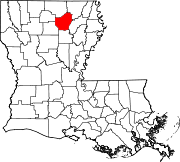
Calhoun, Louisiana
Calhoun is located in a rural area with a landscape mixture of hills and woodlands on the former transcontinental route U.S. 80 near Interstate 20, approximately 10 miles west of West Monroe. It has experienced a large growth in population recently and is near three local universities.
Demographics
| Census | Pop. | Note | %± |
|---|---|---|---|
| 2020 | 670 | — | |
| U.S. Decennial Census | |||
2020 census
| Race | Number | Percentage |
|---|---|---|
| White (non-Hispanic) | 569 | 84.93% |
| Black or African American (non-Hispanic) | 40 | 5.97% |
| Native American | 4 | 0.6% |
| Asian | 2 | 0.3% |
| Other/Mixed | 30 | 4.48% |
| Hispanic or Latino | 25 | 3.73% |
As of the 2020 United States census, there were 670 people, 135 households, and 121 families residing in the CDP.
Climate
According to the Köppen Climate Classification system, Calhoun has a humid subtropical climate, abbreviated "Cfa" on climate maps. The hottest temperature recorded in Calhoun was 110 °F (43.3 °C) on August 18, 1909 and September 1, 2000, while the coldest temperature recorded was −13 °F (−25.0 °C) in February 1899.
| Climate data for Calhoun, Louisiana, 1991–2020 normals, extremes 1892–2022 | |||||||||||||
|---|---|---|---|---|---|---|---|---|---|---|---|---|---|
| Month | Jan | Feb | Mar | Apr | May | Jun | Jul | Aug | Sep | Oct | Nov | Dec | Year |
| Record high °F (°C) | 85 (29) |
90 (32) |
94 (34) |
98 (37) |
100 (38) |
109 (43) |
109 (43) |
110 (43) |
110 (43) |
100 (38) |
90 (32) |
87 (31) |
110 (43) |
| Mean maximum °F (°C) | 75.6 (24.2) |
78.7 (25.9) |
83.9 (28.8) |
87.5 (30.8) |
91.4 (33.0) |
96.2 (35.7) |
99.4 (37.4) |
100.7 (38.2) |
97.2 (36.2) |
90.4 (32.4) |
82.9 (28.3) |
76.7 (24.8) |
101.6 (38.7) |
| Mean daily maximum °F (°C) | 56.8 (13.8) |
61.1 (16.2) |
68.9 (20.5) |
76.4 (24.7) |
83.4 (28.6) |
90.3 (32.4) |
93.2 (34.0) |
93.6 (34.2) |
88.7 (31.5) |
78.2 (25.7) |
67.2 (19.6) |
59.2 (15.1) |
76.4 (24.7) |
| Daily mean °F (°C) | 44.8 (7.1) |
48.3 (9.1) |
56.0 (13.3) |
63.2 (17.3) |
71.4 (21.9) |
78.5 (25.8) |
81.6 (27.6) |
81.3 (27.4) |
75.7 (24.3) |
64.0 (17.8) |
53.9 (12.2) |
46.8 (8.2) |
63.8 (17.7) |
| Mean daily minimum °F (°C) | 32.8 (0.4) |
35.5 (1.9) |
43.0 (6.1) |
50.0 (10.0) |
59.3 (15.2) |
66.7 (19.3) |
70.0 (21.1) |
69.0 (20.6) |
62.7 (17.1) |
49.9 (9.9) |
40.5 (4.7) |
34.5 (1.4) |
51.2 (10.6) |
| Mean minimum °F (°C) | 17.6 (−8.0) |
22.2 (−5.4) |
26.9 (−2.8) |
33.9 (1.1) |
45.8 (7.7) |
57.4 (14.1) |
63.8 (17.7) |
62.0 (16.7) |
47.7 (8.7) |
34.8 (1.6) |
26.5 (−3.1) |
19.5 (−6.9) |
14.6 (−9.7) |
| Record low °F (°C) | −2 (−19) |
−13 (−25) |
14 (−10) |
26 (−3) |
34 (1) |
45 (7) |
52 (11) |
44 (7) |
36 (2) |
24 (−4) |
10 (−12) |
5 (−15) |
−13 (−25) |
| Average precipitation inches (mm) | 5.70 (145) |
4.98 (126) |
5.47 (139) |
5.69 (145) |
5.39 (137) |
4.36 (111) |
4.01 (102) |
3.51 (89) |
3.58 (91) |
4.66 (118) |
4.71 (120) |
5.50 (140) |
57.56 (1,463) |
| Average snowfall inches (cm) | 0.1 (0.25) |
0.0 (0.0) |
0.0 (0.0) |
0.0 (0.0) |
0.0 (0.0) |
0.0 (0.0) |
0.0 (0.0) |
0.0 (0.0) |
0.0 (0.0) |
0.0 (0.0) |
0.0 (0.0) |
0.0 (0.0) |
0.1 (0.25) |
| Average precipitation days (≥ 0.01 in) | 9.3 | 8.6 | 9.0 | 7.4 | 8.1 | 8.6 | 7.7 | 6.3 | 6.1 | 6.8 | 8.0 | 8.7 | 94.6 |
| Average snowy days (≥ 0.1 in) | 0.0 | 0.1 | 0.0 | 0.0 | 0.0 | 0.0 | 0.0 | 0.0 | 0.0 | 0.0 | 0.0 | 0.1 | 0.2 |
| Source 1: NOAA | |||||||||||||
| Source 2: National Weather Service (mean maxima/minima 1981–2010) | |||||||||||||
Education
Ouachita Parish School System is the area school district.
The zoned schools are Calhoun Elementary School (Kindergarten to Grade 2), Central Elementary School (grades 3-5), Calhoun Middle School (grades 6-8), and West Ouachita High School.
Notable people
Former U.S. Representative Newt V. Mills of Louisiana was born in Calhoun.
References
- ^ "2020 U.S. Gazetteer Files". United States Census Bureau. Retrieved March 20, 2022.
- ^ "Calhoun Zipcode". Retrieved April 11, 2019.
- ^ U.S. Geological Survey Geographic Names Information System: Calhoun, Louisiana
- ^ "Census of Population and Housing". Census.gov. Retrieved June 4, 2016.
- ^ "Explore Census Data". data.census.gov. Retrieved December 29, 2021.
- ^ "NOAA Online Weather Data – NWS Shreveport". National Weather Service. Retrieved February 20, 2023.
- ^ "U.S. Climate Normals Quick Access – Station: Calhoun RSCH STN, LA". National Oceanic and Atmospheric Administration. Retrieved February 20, 2023.
- ^ "2020 CENSUS - SCHOOL DISTRICT REFERENCE MAP: Ouachita Parish, LA" (PDF). U.S. Census Bureau. pp. 10-11 (PDF pp. 11-12/31). Retrieved January 4, 2025. - Text list
- ^ "Feeder Schools Correlation" (PDF). Ouachita Parish School Board. Retrieved January 4, 2024. - Linked from here. Calhoun ES boundary map and Central ES boundary map. The Calhoun schools feed into West Ouachita High.
- ^ "Mills, Newt Vergus (1899-1996)". bioguide.congress.gov. Retrieved September 25, 2014.
External links
