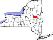
Caroga Lake, New York
Geography
The community of Caroga Lake is situated in northern Fulton County in the southern Adirondack Mountains, centered on a peninsula between West Caroga Lake to the west and East Caroga Lake to the south. The CDP area includes both of the lakes and the developed land surrounding the lakes. According to the United States Census Bureau, the CDP has a total area of 3.4 square miles (8.7 km), of which 2.5 square miles (6.5 km) is land and 0.89 square miles (2.3 km), or 25.89%, is water.
New York State Routes 10 and 29A intersect at the center of the community. NY 10 leads north 24 miles (39 km) to Piseco Lake and south 19 miles (31 km) to Canajoharie on the Mohawk River, while NY 29A leads southeast 10 miles (16 km) to Gloversville. NY 29A follows NY 10 to the northwest out of town, then turns west towards Stratford, 14 miles (23 km) from Caroga Lake.
Demographics
| Census | Pop. | Note | %± |
|---|---|---|---|
| 2020 | 548 | — | |
| U.S. Decennial Census | |||
Recreational Opportunities
Caroga Lake CDP area was home to Sherman's Restaurant and Amusement Park from 1921 until the early 1970s. The shell of a park now hosts music and art events, including live bands and a fireworks show every 4 July.
There is a New York State Campground located on the shore of East Caroga Lake that features 105 campsites, a picnic area, sandy beach, trailer dump station, bathhouse, hot showers and toilets.
References
- ^ "ArcGIS REST Services Directory". United States Census Bureau. Retrieved September 20, 2022.
- ^ "Geographic Identifiers: 2010 Census Summary File 1 (G001), Caroga Lake CDP, New York". American FactFinder. U.S. Census Bureau. Archived from the original on February 13, 2020. Retrieved June 23, 2016.
- ^ "Census of Population and Housing". Census.gov. Retrieved June 4, 2016.
- ^ "Exploring the History of Sherman's Amusement Park". spectrumlocalnews.com. Retrieved March 6, 2020.
- ^ "Caroga Lake Campground & Day Use Area". dec.ny.gov. Retrieved March 6, 2020.
