Chamchamal
Chamchamal (Kurdish: چهمچهماڵ, romanized: Çemçemal, Arabic: جمجمال) is a town located in Sulaymaniyah Governorate, Kurdistan Region, Iraq. it is the town which is nearest located to the disputed territories of Northern Iraq. Chamchamal is home to the Gorani-speaking Hamawand tribe.
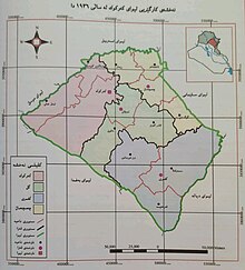
Map of Kirkuk in 1936 including chamchamal
Population and location
The city is a 30 minutes drive east from Kirkuk and an hour west of Sulaymaniyah. The population was 58,000 in 2003. The population in 2018 was 65,300 people, the vast majority being Kurds.
History
The city has a historic citadel, and early Western observers of the region speculated that it has been inhabited since the Sassanid period. The Chamchamal valley is also home to important paleolithic sites of Jarmo and Zarzi. The city broke away from Kirkuk in 1976 and was given to Sulaymaniyah.

Climate
| Climate data for Chamchamal | |||||||||||||
|---|---|---|---|---|---|---|---|---|---|---|---|---|---|
| Month | Jan | Feb | Mar | Apr | May | Jun | Jul | Aug | Sep | Oct | Nov | Dec | Year |
| Mean daily maximum °C (°F) | 10.3 (50.5) |
12.2 (54.0) |
16.6 (61.9) |
22.6 (72.7) |
30.1 (86.2) |
36.7 (98.1) |
40.4 (104.7) |
40.2 (104.4) |
36.2 (97.2) |
29.5 (85.1) |
20.1 (68.2) |
13.0 (55.4) |
25.7 (78.2) |
| Mean daily minimum °C (°F) | 1.3 (34.3) |
2.5 (36.5) |
6.0 (42.8) |
10.6 (51.1) |
15.8 (60.4) |
21.3 (70.3) |
24.6 (76.3) |
24.7 (76.5) |
20.3 (68.5) |
14.9 (58.8) |
8.6 (47.5) |
3.3 (37.9) |
12.8 (55.1) |
| Average precipitation mm (inches) | 126 (5.0) |
104 (4.1) |
108 (4.3) |
60 (2.4) |
29 (1.1) |
0 (0) |
0 (0) |
0 (0) |
0 (0) |
5 (0.2) |
47 (1.9) |
86 (3.4) |
565 (22.2) |
| Source: Climate-data.org | |||||||||||||
Notable people
- Thanun Pyriadi (born 1933), chemist, from Ali Mansour village
See also
- Garmekan (Sasanian province located in modern-day Kurdistan Region of Iraq)
- Garmian Region
- Beth Garmai
References
- ^ "نووسینگهی پاسپۆرت له قهزای چهمچهماڵ دهكرێتهوه". www.peyam.net (in Kurdish).
- ^ "Li Çemçemal û Silêmaniyeyê çalakiyên ciwanan -NÛ BÛ". ANF News (in Kurdish). Retrieved 20 December 2019.
- ^ "Country Policy and Information Note Iraq: Blood feuds". 2017. p. 9. Archived from the original on 20 December 2019. Retrieved 20 December 2019.
- ^ "Letter From Chamchamal, Iraq — March 17, 2003". Poynter. Retrieved 2016-01-20.
- ^ "Historic landmarks under threat in Chamchamal, Iraqi Kurdistan". ekurd.net. 2009-09-01. Retrieved 2016-01-20.
- ^ (UNESCO), Sanz, Nuria (2015-09-07). Human origin sites and the World Heritage Convention in Eurasia. UNESCO Publishing. ISBN 9789231001079.
{{cite book}}: CS1 maint: multiple names: authors list (link)

This Kurdistan geographical location article is a stub. You can help Wikipedia by expanding it. |