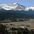
Chinook Peak (Alberta)
Description
Chinook Peak is situated 10 kilometers southwest of the town of Coleman in the Crowsnest Pass area and can be seen from Highway 3, the Crowsnest Highway. It is set on land managed by Castle Wildland Provincial Park. Precipitation runoff from the mountain drains into tributaries of the nearby Crowsnest River. Topographic relief is significant as the summit rises 1,300 meters (4,265 feet) above the river in 4.5 kilometers (2.8 miles). Sentry Mountain is 4.0 km (2.5 mi) to the northwest and the nearest higher neighbor is Andy Good Peak, 3.0 km (1.9 mi) to the southeast on the Continental Divide.
History
Chinook Peak was named by Jim Kerr, a resident of the Crowsnest Pass. Jim knew that when snow started blowing from the top from the west, a chinook wind would soon follow. When mapping this area, Dr. Raymond A. Price of the Geological Survey of Canada mapping this area, used this name to identify the peak. The mountain's toponym was officially adopted in 1962 by the Geographical Names Board of Canada.
Geology
Chinook Peak is composed of sedimentary rock laid down during the Precambrian to Jurassic periods. Formed in shallow seas, this sedimentary rock was pushed east and over the top of younger Cretaceous period rock during the Laramide orogeny.
Climate
Based on the Köppen climate classification, Chinook Peak has an alpine subarctic climate with cold, snowy winters, and mild summers. Temperatures can drop below −20 °C with wind chill factors below −30 °C.
Gallery
See also
References
- ^ Aphrodite Karamitsanis (1991), Place Names of Alberta, Vol I: Mountains, mountain parks, and foothills, University of Calgary Press, ISBN 978-0919813731, p. 49
- ^ "Chinook Peak". cdnrockiesdatabases.ca. Retrieved 2022-09-17.
- ^ Chinook Peak, Peakvisor.com
- ^ "Chinook Peak". Geographical Names Data Base. Natural Resources Canada. Retrieved 2022-09-17.
- ^ "Flathead Range". Geographical Names Data Base. Natural Resources Canada. Retrieved 2022-09-17.
- ^ Gadd, Ben (2008), Geology of the Rocky Mountains and Columbias
- ^ Peel, M. C.; Finlayson, B. L.; McMahon, T. A. (2007). "Updated world map of the Köppen−Geiger climate classification". Hydrol. Earth Syst. Sci. 11 (5): 1633–1644. Bibcode:2007HESS...11.1633P. doi:10.5194/hess-11-1633-2007. ISSN 1027-5606.
External links
- Chinook Peak weather forecast
- Climbing Chinook Peak (photos): Anugara.net


