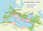
Creta Et Cyrenaica
Apion's will and Roman rule of Cyrenaica
Ptolemy Apion, the last king of the Hellenistic Kingdom of Cyrenaica left his kingdom to the Roman Republic when he died childless in 96 BC. Rome readily accepted this inheritance from Ptolemy Apion but preferred to leave the administration to local rulers, rather than enforcing direct control. However, by the 70s BC, civil uprisings by Jewish settlers began to destabilise the province and the Senate was forced to take action. In 74 BC, they sent a low level official, the quaestor Cornelius Lentulus Marcellinus, to officially annex Cyrenaica as a Roman province and restore order. That the Senate sent such a low-ranking official indicates the political difficulty the Republic had in governing its growing empire, as well as indicating the ease with which Cyrenaica was willing to submit to Roman governance and the stability it brought.
Roman conquest of Crete
Marcus Antonius Creticus attacked Crete in 71 BC and was repelled. Then in 69 BC, Rome commissioned Quintus Caecilius Metellus and, following a ferocious three-year campaign, Crete was conquered for Rome in 66 BC, Metellus earning the agnomen "Creticus" as an honour for his conquest and subjugation of Crete.
Province
In 67 BC, Crete and Cyrenaica were combined into a single province with its capital at Gortyn in Crete. In 117 AD, a Jewish revolt erupted in Cyrenaica, resulting in the death of two hundred and twenty thousand people. In 298 AD, Diocletian, because of geographic inconvenience, separated the province of Crete from Cyrenaica, which in turn was divided between Libya Superior or Libya Pentapolis, with Cyrene as its capital, and Libya Inferior or Libya Sicca, with Paraetonium as its capital.
List of Roman governors
- C. Clodius Vestalis (between 30 BC and AD 14)
- M. Titius (between 30 BC and AD 14)
- Pomponius Secundus (between AD 37 and 54)
- Fabius (before 13 BC)
- P. Sextius Scaeva (7/6 BC)
- Q. Lucanius Proculus (after 13 BC)
- L. Plotius Vicinas (between 2 BC and AD 7)
- (Lollius) Palicanus (between 30 BC and AD 14)
- Marcus Nonius Balbus (between 30 BC and AD 14)
- (Vettius) Scato (between 23 BC and AD 12)
- Gaius Rubellius Blandus (between 30 BC and AD 14)
- (Titus) Caesius Cordus (c. AD 12)
- P. Octavius (between AD 14 and 29)
- Occius Flamma (between AD 14 and 37)
- Cornelius Lupus (between AD 14 and 37)
- P. Viriasius Naso
- Celer
- Augurinus (between AD 37 and 41)
- Q. Cassius Gratus (before 53)
- Caesernius Veiento (46/47?)
- Publius Pomponius Secundus (between 37 and 54)
- Cestius Proculus (before 56)
- Pedius Blaesus (before 59)
- Bruttidius Sabinus (first half 1st century)
- Lucius Turpilius Dexter (64/65)
- Titus Atilius Rufus (67)
- Aulus Minicius Rufus (71/72)
- Catullus (72/73)
- Gaius Arinius Modestus (73-75)
- Silo
- Aulus Julius Quadratus (84/85)
- Gaius Pomponius Gallus Didius Rufus (88/89)
- Gaius Memmius [...] (98/99)
- Lucius Elufrius Severus (99/100)
- Lucius Aemilius Honoratus (between 97 and 118)
- Titus Vibius Varus (between 97 and 118)
- Salvius Carus (134/135)
- Quintus Caecilius Marcellus Dentilianus (c. 140)
- Quintus Julius Potitus (between 138 and 161)
- Gaius Claudius Titianus Demostratus (161/162)
- Pomponius Naevianus (between 165 and 169)
- Veturius Paccianus (before 168)
- Lucius Saevinius Proculus (173/174)
- Quintus Caecilius Rufinus (between 160 and 180)
- Quintus Servilius Pudens (164/165)
- Lucius Clodius Tineius Pupienus Bassus (250)
Further reading
- Jane Francis and Anna Kouremenos (eds.) 2016. Roman Crete: New Perspectives. Oxford: Oxbow
- Anna Kouremenos 2018. "In the Heart of the Wine-Dark Sea: Cretan Insularity and Identity in the Roman Period". In A. Kouremenos (ed.) Insularity and Identity in the Roman Mediterranean. Oxford: Oxbow.
- Francis, Jane; Curtis, Michael J., eds. (2022). Change and transition on Crete interpreting the evidence from the Hellenistic through to the early Byzantine period. Oxford: Archaeopress Archaeology. ISBN 9781803270562.
References
- ^ "Ptolemy Apion". Chris Bennett. Retrieved 2016-11-24.
- ^ "Cyrenaica". UNRV.com. Retrieved 2016-11-24.
- ^ "Crete". UNRV.com. Retrieved 2016-11-24.
- ^ "Cyrenaica historical region, North Africa". Encyclopaedia Britannica. Retrieved 27 December 2017.
- ^ Smallwood, Edith M. (1981). The Jews Under Roman Rule: From Pompey to Diocletian: a Study in Political Relations. BRILL. p. 394. ISBN 978-90-04-06403-4.
- ^ "Cyernaica". Livius.org. Retrieved 2016-11-24.
- ^ Unless otherwise stated, the names of the proconsular governors from 30 BC to AD 67 are taken from Werner Eck, "Über die prätorischen Prokonsulate in der Kaiserzeit. Eine quellenkritische Überlegung", Zephyr 23/24 (1972/73), pp. 246f
- ^ Unless otherwise stated, the names of the proconsular governors from 71 to 135 are taken from Werner Eck, "Jahres- und Provinzialfasten der senatorischen Statthalter von 69/70 bis 138/139", Chiron, 12 (1982), pp. 281-362; 13 (1983), pp. 147-237
- ^ Unless otherwise stated, the names of the proconsular governors from 140 to 165 are taken from Géza Alföldy, Konsulat und Senatorenstand unter der Antoninen (Bonn: Rudolf Habelt Verlag, 1977), pp. 263f
