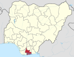
Degema, Nigeria
Degema is situated in Rivers State in the South South geo-political zone of Nigeria and has its headquarters in the town of Degema. The population of Degema Local Government Area is 249,773 (2006 census) with the majority of the people residing there having Ijaw ancestry. It has an area of 1,011 km2.
In the early 19th century, after slave trade it was a major exporter of kernels and palm oil and it is located in an area of mangroves, tropical forests and swamps. The Ijaw and Degema dialects are widely spoken in the area while Christianity is the common religion practiced in the area. Degema is home to a number of festivals which includes the Agiri and Igugule festivals while the popular landmarks in the area includes the Degema General Hospital, Medium Security Custodial Center, Degema, Zonal Hospital Degema, RT Hon. Tonye E. Harry Stadium, A Comprehensive Health center.
The postal code of the area is 504. Degema shares border with Asari Toru to the North, Akuku-Toru to the west, Okrika and Bonny to the east, and a river to the south.
Climate
Degema has a hot, humid climate that experiences uncomfortable weather all year round. The wet season is warm and cloudy. It rarely drops below 64°F or rises beyond 90°F throughout the year, usually fluctuating between 71°F and 87°F yearly.
List of communities and towns in Degema LGA
The towns and villages that make up Degema LGA includes Degema, Bakana, Usokun-Degema, Ogurama, Tombia, Ke, Bille, Obuama and Bukuma. Other villages are; Adumu-ama, Angalabio, Elem-Sangana, Fouche, Idama, Kala-Degema, Obuama, Old-Bakan, Opukiri, Oru-Sangama, Tombia and others.
References
- ^ "Degema Local Government Area". www.finelib.com. Retrieved 2023-05-05.
- ^ "Degema | Nigeria | Britannica". www.britannica.com. Retrieved 2023-05-01.
- ^ "Degema Local Government Area". www.manpower.com.ng. Retrieved 2021-09-15.
- ^ "Post Offices- with map of LGA". NIPOST. Archived from the original on 2009-10-07. Retrieved 2009-10-20.
- ^ "Degema Climate, Weather By Month, Average Temperature (Nigeria) - Weather Spark". weatherspark.com. Retrieved 2024-08-09.
- ^ "Degema, Rivers, NG Climate Zone, Monthly Averages, Historical Weather Data". weatherandclimate.com. Retrieved 2024-08-09.
- ^ "Degema Local Government Area". www.finelib.com. Retrieved 2023-05-05.
