Dewey Peak
Climate

Dewey Peak is located in the marine west coast climate zone of western North America. Most weather fronts originating in the Pacific Ocean travel northeast toward the Cascade Mountains. As fronts approach, they are forced upward by the peaks of the Cascade Range (orographic lift), causing them to drop their moisture in the form of rain or snow onto the Cascades. As a result, the west side of the Cascades experiences high precipitation, especially during the winter months in the form of snowfall. Because of maritime influence, snow tends to be wet and heavy, resulting in high avalanche danger. During winter months, weather is usually cloudy, but due to high pressure systems over the Pacific Ocean that intensify during summer months, there is often little or no cloud cover during the summer.
References
- ^ "Dewey Peak, Washington". Peakbagger.com.
- ^ ""Dewey Peak" - 6,710' WA". listsofjohn.com. Retrieved July 8, 2020.
- ^ Beckey, Fred W. Cascade Alpine Guide, Climbing and High Routes. Seattle, WA: Mountaineers Books, 2008.
Gallery
-
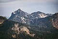 Dewey Peak seen from northwest
 -
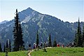 Dewey Peak seen from Naches Peak Loop Trail


External links
- National Park Service web site: Mount Rainier National Park
- National Forest Service web site: William O Douglas Wilderness