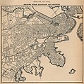
File:1880 Boston Railroads Map.jpg
Click on a date/time to view the file as it appeared at that time.
| Date/Time | Thumbnail | Dimensions | User | Comment | |
|---|---|---|---|---|---|
| current | 19:39, 30 September 2006 |  | 1,546 × 1,554 (654 KB) | Beland | Map of Boston in 1880, highlighting railroads and railroad stations. * Source: http://www.lib.utexas.edu/maps/historical/boston_railroad_1880.jpg * License: Public domain according to http://www.lib.utexas.edu/usage_statement.html?maps=yes |
File usage
The following pages on the English Wikipedia use this file (pages on other projects are not listed):
Global file usage
The following other wikis use this file:
- Usage on ar.wikipedia.org
- Usage on de.wikipedia.org
- Usage on fr.wikipedia.org
- Usage on id.wikipedia.org
- Usage on ko.wikipedia.org
- Usage on ru.wikipedia.org
- Usage on uk.wikipedia.org
- Usage on uz.wikipedia.org
- Usage on zh.wikipedia.org