File:1929 Bahamas Hurricane Andros Island Map.JPG
العربية ∙ čeština ∙ Deutsch ∙ Zazaki ∙ English ∙ español ∙ eesti ∙ suomi ∙ français ∙ hrvatski ∙ magyar ∙ italiano ∙ 日本語 ∙ 한국어 ∙ македонски ∙ മലയാളം ∙ Plattdüütsch ∙ Nederlands ∙ polski ∙ português ∙ română ∙ русский ∙ sicilianu ∙ slovenščina ∙ Türkçe ∙ Tiếng Việt ∙ 简体中文 ∙ 繁體中文 ∙ +/−

|
Original upload log
The original description page was
here. All following user names refer to en.wikipedia.
Upload date | User | Bytes | Dimensions | Comment
- 2006-04-28 16:35:05 | Storm05 | 667677 | 1768×1932 | handwitten picture of the 1929 Hurricane hitting Andros Island. http://www.aoml.noaa.gov/hrd/hurdat/rosenberg.pdf {{PD-USGov-DOC-NOAA}}
Add a one-line explanation of what this file represents
Click on a date/time to view the file as it appeared at that time.
| Date/Time | Thumbnail | Dimensions | User | Comment |
|---|
| current | 16:34, 3 January 2012 | 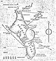 | 1,768 × 1,932 (652 KB) | Hurricanefan25 | =={{int:filedesc}}== {{Information |description=A handwritten map depicting the 1929 Bahamas hurricane striking Andros Island. |date=2012-01-03 16:32:19(UTC) (Originally uploaded at 2006-04-28 16:35:05) |source=[http://www.aoml.noaa.gov/hrd/hurdat/rosenbe |
The following pages on the English Wikipedia use this file (pages on other projects are not listed):
The following other wikis use this file:
- Usage on www.wikidata.org
