File:1954-OrientPointLight-USGSMap.jpg
Bahasa Indonesia ∙ català ∙ čeština ∙ Deutsch ∙ eesti ∙ English ∙ español ∙ français ∙ galego ∙ italiano ∙ Nederlands ∙ português ∙ polski ∙ sicilianu ∙ suomi ∙ Tiếng Việt ∙ Türkçe ∙ български ∙ македонски ∙ русский ∙ മലയാളം ∙ 한국어 ∙ 日本語 ∙ 中文 ∙ 中文(简体) ∙ 中文(繁體) ∙ العربية ∙ فارسی ∙ +/−

|
Original upload log
Transferred from en.wikipedia to Commons by Dharmadhyaksha using CommonsHelper.
The original description page was
here. All following user names refer to en.wikipedia.
- 2009-10-13 16:19 Neighborhoodpalmreader 1015×693× (163330 bytes) {{Information |Description={{en|1=1954 USGS map - Plum Island Quadrangle}} showing Orient Point Light |Source=1954 USGS map - Plum Island Quadrangle |Author=USGS |Date=1954 |Permission= |other_versions= }} == Licensing == {{PD-USGov-USGS}}
Add a one-line explanation of what this file represents
Click on a date/time to view the file as it appeared at that time.
| Date/Time | Thumbnail | Dimensions | User | Comment |
|---|
| current | 04:20, 12 October 2012 | 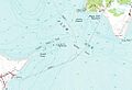 | 1,015 × 693 (160 KB) | File Upload Bot (Magnus Manske) | Transfered from en.wikipedia by User:Dharmadhyaksha using CommonsHelper |
The following pages on the English Wikipedia use this file (pages on other projects are not listed):
