File:506-Castile 1210.png
Click on a date/time to view the file as it appeared at that time.
| Date/Time | Thumbnail | Dimensions | User | Comment | |
|---|---|---|---|---|---|
| current | 20:58, 12 May 2010 | 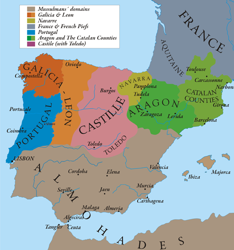 | 474 × 506 (138 KB) | Alexandre Vigo~commonswiki | {{Information |Description={{en|1=This map show Al-Andalus (Almohades) and European Christian kingdoms. 12th-13th centuries. It´s made from "The Historical Atlas by William R. Shepherd, 1926".}} |Source={{own}} |Author=[[User:Alexandre Vigo|Alexandre Vig |
File usage
The following pages on the English Wikipedia use this file (pages on other projects are not listed):
Global file usage
The following other wikis use this file:
- Usage on ar.wikipedia.org
- Usage on arz.wikipedia.org
- Usage on ast.wikipedia.org
- Usage on azb.wikipedia.org
- Usage on az.wikipedia.org
- Usage on ba.wikipedia.org
- Usage on be.wikipedia.org
- Usage on br.wikipedia.org
- Usage on ca.wikipedia.org
- Usage on cs.wikipedia.org
- Usage on cy.wikipedia.org
- Usage on de.wikipedia.org
- Usage on en.wikibooks.org
- Usage on es.wikipedia.org
- Usage on et.wikipedia.org
- Usage on fa.wikipedia.org
- Usage on fr.wikipedia.org
- Aragon
- Conquête almohade d'al-Andalus
- Royaume de Castille
- Espagnes médiévales
- Histoire d'al-Andalus
- Géographie d'al-Andalus
- Formation territoriale de l'Espagne
- Histoire de l'Occitanie
- Histoire des grandes puissances
- Liste des commanderies templières en Castille-et-León
- Liste des commanderies templières en Galice
- Portail:Castille-et-León/Lumière sur...
- Liste des commanderies templières dans la Rioja
- Liste des maîtres de la province de Castille et León de l'ordre du Temple
- Usage on fy.wikipedia.org
- Usage on ga.wikipedia.org
- Usage on gl.wikipedia.org
View more global usage of this file.