Loading
  • 21 Aug, 2019

  • By, Wikipedia

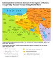
File:ATD Of The Regions Of Turkey Occupied By Russian Troops During WW1.png


This historical map image could be re-created using vector graphics as an SVG file. This has several advantages; see Commons:Media for cleanup for more information. If an SVG form of this image is available, please upload it and afterwards replace this template with {{vector version available|new image name}}.


It is recommended to name the SVG file “ATD of the regions of Turkey occupied by Russian troops during WW1.svg”—then the template Vector version available (or Vva) does not need the new image name parameter.

Captions

Add a one-line explanation of what this file represents

Items portrayed in this file

depicts

17 December 2018

image/png

df5386c67a411fc1ea4da2c96090536777286ade

195,452 byte

1,352 pixel

1,232 pixel

File history

Click on a date/time to view the file as it appeared at that time.

Date/TimeThumbnailDimensionsUserComment
current14:22, 11 May 2021Thumbnail for version as of 14:22, 11 May 20211,232 × 1,352 (191 KB)Accipite7Colors have been improved.
14:47, 29 April 2021Thumbnail for version as of 14:47, 29 April 20211,232 × 1,352 (191 KB)Accipite7Improved colors
14:42, 29 April 2021Thumbnail for version as of 14:42, 29 April 20211,232 × 1,352 (191 KB)Accipite7Updated the names of cities in different languages.
11:03, 17 December 2018Thumbnail for version as of 11:03, 17 December 20181,232 × 1,352 (158 KB)Accipite7Cross-wiki upload from ru.wikipedia.org

Global file usage

Metadata