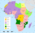
File:Africa Map 1939, Colours.svg
}}
Click on a date/time to view the file as it appeared at that time.
| Date/Time | Thumbnail | Dimensions | User | Comment | |
|---|---|---|---|---|---|
| current | 14:23, 16 December 2023 |  | 1,430 × 1,350 (1.81 MB) | Hogweard | Minor font issue |
| 22:56, 14 December 2023 |  | 1,430 × 1,350 (1.81 MB) | Hogweard | {{Information |Description=A map of Africa in 1939, with colours for the sovereign powers |Source={{f|Africa map 1935, colours 2.svg}} |Date=2023-12-14 |Author={{u|Hogweard}} |Permission={{PD-self}} |other_versions= }} Category:SVG maps showing history of Africa Category:Maps of 20th-century Africa}} |
The following other wikis use this file: