Loading
  • 21 Aug, 2019

  • By, Wikipedia

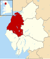
File:Allerdale UK Locator Map.svg

This image is a derivative work of the following images:

  • File:Cumbria UK district map (blank).svg licensed with Cc-by-sa-3.0
    • 2010-08-22T08:05:20Z Nilfanion 1140x1345 (1260695 Bytes) +inset, water colour tweak
    • 2010-07-16T23:26:45Z Nilfanion 1140x1345 (885109 Bytes) {{Information |Description=Map of [[w:Cumbria|Cumbria]], UK with districts shown. Equirectangular map projection on WGS 84 datum, with N/S stretched 170% Geographic limits: *West: 3.80W *East: 2.10W *North: 55.20N *South: 5
Captions

Add a one-line explanation of what this file represents

Items portrayed in this file

depicts

16 August 2011

image/svg+xml

ce4977fefb68e649526a496dc7e4b8dc5142b2f6

1,262,348 byte

1,345 pixel

1,140 pixel

File history

Click on a date/time to view the file as it appeared at that time.

Date/TimeThumbnailDimensionsUserComment
current13:27, 16 August 2011Thumbnail for version as of 13:27, 16 August 20111,140 × 1,345 (1.2 MB)Renly~commonswiki{{Information |Description=Map of Cumbria, with Allerdale highlighted. |Source=*File:Cumbria UK district map (blank).svg |Date=2011-08-16 13:26 (UTC) |Author=*File:Cumbria UK district map (blank).svg: Nilfanion, created usin

The following page uses this file:

Global file usage

The following other wikis use this file: