File:Anzac Landing Plan April 25 1915.jpg
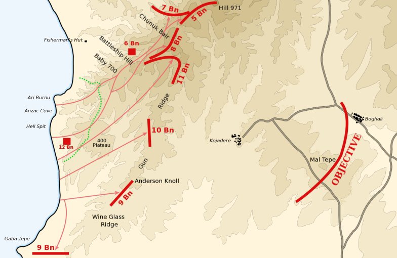
Map of the planned landing of the 2nd and 3rd Brigades of the Australian 1st Division north of Gaba Tepe on April 25, 1915 during the en:Battle of Gallipoli. The red lines mark the first day objectives. The dotted green line marks the advance achieved on the first day. Contours are at 50 metre intervals.
Derived from Map No. 7 in Ch.11, Vol. I "The Story of Anzac" of the en:Official History of Australia in the War of 1914-18 by en:C.E.W. Bean.
Date
13 March 2004 (original upload date)
Source
Transferred from en.wikipedia to Commons.
Author
Gsl at English Wikipedia
Licensing
| This work has been released into the public domain by its author, Gsl at English Wikipedia. This applies worldwide. In some countries this may not be legally possible; if so: Gsl grants anyone the right to use this work for any purpose, without any conditions, unless such conditions are required by law. |
Original upload log
The original description page was here. All following user names refer to en.wikipedia.
- 2004-03-13 11:18 Gsl 784×510×8 (65265 bytes)

|
This battle map image could be re-created using vector graphics as an SVG file. This has several advantages; see Commons:Media for cleanup for more information. If an SVG form of this image is available, please upload it and afterwards replace this template with
{{vector version available|new image name}}.
It is recommended to name the SVG file “Anzac landing plan April 25 1915.svg”—then the template Vector version available (or Vva) does not need the new image name parameter. |


