File:Aral Sea.gif
Own work using:
Author
NordNordWest
Other versions
- NASA images
- United States National Imagery and Mapping Agency data
- www.unimaps.com
- Aralsee.gif German version
- Aralskoje more.gif Russian version
Assessment
| This file was selected as the media of the day for 5 January 2021. It was captioned as follows:
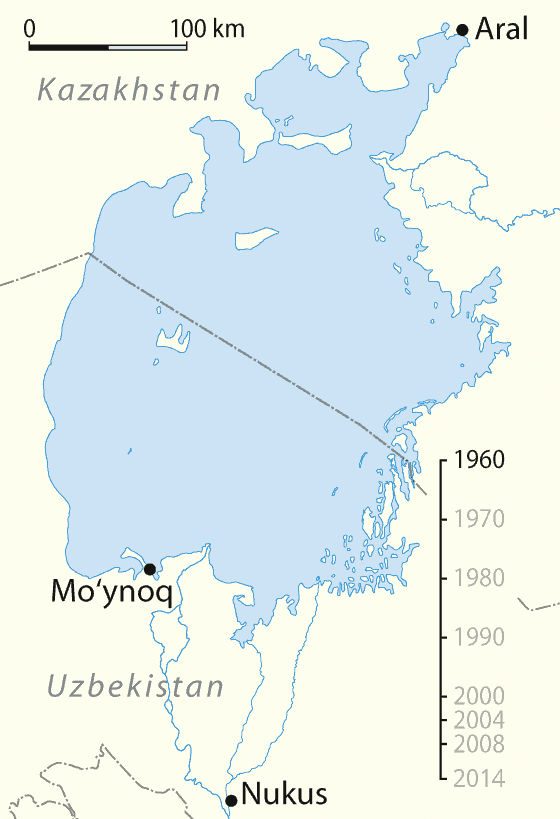
English: Aral Sea, timeline of shrinking.
Other languages
العربية: البيان الزمني لتقلص بحر آرال. Čeština: Vysychání (zmenšování plochy) Aralského jezera v období let 1960 - 2014. English: Aral Sea, timeline of shrinking. Français : Animation de l'assèchement de la mer d'Aral entre 1960 et 2014. Эрзянь: Аралонь иневедень ёмавтомась-вишкалговтомась шкасо. Русский: Снижение уровня Аральского моря
|

|
This map has been made or improved in the German Kartenwerkstatt (Map Lab). You can propose maps to improve as well.
|
Licensing
I, the copyright holder of this work, hereby publish it under the following licenses:

|
Permission is granted to copy, distribute and/or modify this document under the terms of the GNU Free Documentation License, Version 1.2 or any later version published by the Free Software Foundation; with no Invariant Sections, no Front-Cover Texts, and no Back-Cover Texts. A copy of the license is included in the section entitled GNU Free Documentation License. |
This file is licensed under the Creative Commons Attribution-Share Alike 3.0 Unported license.
- You are free:
- to share – to copy, distribute and transmit the work
- to remix – to adapt the work
- Under the following conditions:
- attribution – You must give appropriate credit, provide a link to the license, and indicate if changes were made. You may do so in any reasonable manner, but not in any way that suggests the licensor endorses you or your use.
- share alike – If you remix, transform, or build upon the material, you must distribute your contributions under the same or compatible license as the original.
You may select the license of your choice.


