Click on a date/time to view the file as it appeared at that time.
| Date/Time | Thumbnail | Dimensions | User | Comment |
|---|
| current | 19:15, 1 December 2011 |  | 1,100 × 1,446 (1,017 KB) | Lin linao | Mejora de resolución y corrección de las bahías y fiordos que estaban marcados como cuerpos de agua interior. |
| 16:29, 5 September 2007 | 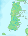 | 280 × 369 (21 KB) | Lin linao | {{Information |Description={{es|Mapa del Archipiélago de Chiloé (Chile)}} |Source= {{es|Mapa en el dominio público}}{{en|PD map}} |Date=5 de septiembre, 2007 |Author= Lin linao |Permission={{Demis |
The following other wikis use this file:
- Usage on ar.wikipedia.org
- Usage on bg.wikipedia.org
- Usage on br.wikipedia.org
- Usage on ca.wikipedia.org
- Usage on ceb.wikipedia.org
- Usage on cs.wikipedia.org
- Usage on da.wikipedia.org
- Usage on de.wikipedia.org
- Usage on eo.wikipedia.org
- Usage on es.wikipedia.org
View more global usage of this file.
This file contains additional information, probably added from the digital camera or scanner used to create or digitize it.
If the file has been modified from its original state, some details may not fully reflect the modified file.

