File:Ariake Sea Coastline.png
Click on a date/time to view the file as it appeared at that time.
| Date/Time | Thumbnail | Dimensions | User | Comment | |
|---|---|---|---|---|---|
| current | 04:29, 7 April 2006 | 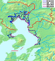 | 180 × 200 (22 KB) | Pekachu | *Historical map of Ariake sea(coastline). *有明海の海岸線の変遷 *fromw:ja:画像:Topographic N30E125 5deg.png, w:ja:画像:Topographic N30E130 5deg.png, w:ja:画像:Japan_pref-16c.png. Category:Maps of Japan[[ |
File usage
The following pages on the English Wikipedia use this file (pages on other projects are not listed):
Global file usage
The following other wikis use this file:
- Usage on de.wikipedia.org
- Usage on es.wikipedia.org
- Usage on fr.wikipedia.org
- Usage on id.wikipedia.org
- Usage on ja.wikipedia.org
- Usage on ja.wikibooks.org
- Usage on pl.wikipedia.org
- Usage on th.wikipedia.org