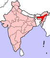
File:Assam In India.png
Click on a date/time to view the file as it appeared at that time.
| Date/Time | Thumbnail | Dimensions | User | Comment | |
|---|---|---|---|---|---|
| current | 07:27, 23 April 2005 |  | 350 × 426 (76 KB) | Nichalp | NPOV map |
| 07:21, 23 April 2005 |  | 200 × 231 (22 KB) | Kerpal | Reverted to earlier revision | |
| 06:16, 23 April 2005 |  | 500 × 608 (121 KB) | Nichalp | Reverted to earlier revision | |
| 04:59, 23 April 2005 |  | 200 × 231 (22 KB) | Kerpal | Reverted to earlier revision | |
| 04:50, 23 April 2005 |  | 500 × 608 (121 KB) | Nichalp | Reverted to earlier revision | |
| 21:04, 22 April 2005 |  | 200 × 231 (22 KB) | Kerpal | Reverted to earlier revision | |
| 13:39, 22 April 2005 |  | 500 × 608 (121 KB) | Nichalp | Reverted to earlier revision | |
| 13:35, 22 April 2005 |  | 500 × 608 (121 KB) | Nichalp | Reverted to earlier revision | |
| 09:55, 22 April 2005 |  | 200 × 231 (22 KB) | Kerpal | originally by en:User:Morwen | |
| 17:49, 21 April 2005 |  | 500 × 608 (121 KB) | Nichalp | Map made by me, ~~~ Note: The Indian state of w:Jammu and Kashmir is claimed by w:India, w:Pakistan and the w:People's Republic of China. This map depicts the boundaries of the state as it was in 1947. Areas administered by India is colo |
File usage
The following pages on the English Wikipedia use this file (pages on other projects are not listed):
- 2004 Indian general election in Assam
- 2008 Assam bombings
- 2009 Assam bombings
- 2009 Guwahati bombings
- 2012 Assam violence
- 2014 Indian general election in Assam
- Ahom kingdom
- Assam Movement
- Assam separatist movements
- Asura kingdom
- Bhauma dynasty
- Chutia Kingdom
- Colonial Assam
- Danava dynasty
- Dark Age of the Assamese language
- Dimasa Kingdom
- History of Assam
- Kamarupa
- Kamata Kingdom
- Koch–Ahom relations
- Operation Bajrang
- Timeline of history of Assam
- Template:History of Assam
Global file usage
The following other wikis use this file:
- Usage on as.wikipedia.org
- Usage on bn.wikipedia.org
- Usage on bs.wikipedia.org
- Usage on bxr.wikipedia.org
- Usage on en.wikinews.org
- Usage on hi.wikipedia.org
- Usage on ka.wikipedia.org
- Usage on pl.wikipedia.org
- Asam
- Guwahati
- Tezpur
- Dispur
- Dibrugarh
- Sonitpur
- Zamachy w Guwahati (6 kwietnia 2009)
- Zamachy w Guwahati (1 stycznia 2009)
- Cachar
- Szablon:Stan Asam
- Barpeta (dystrykt)
- Barpeta
- Baksa (dystrykt)
- Bongaigaon (dystrykt)
- Bongaigaon
- Chirang
- Darrang
- Dhemaji (dystrykt)
- Dhubri (dystrykt)
- Dibrugarh (dystrykt)
- Nagaon (dystrykt)
- Goalpara (dystrykt)
- Goalpara
- Diphu
- Golaghat (dystrykt)
- Dhubri
- Hailakandi (dystrykt)
- Usage on pl.wikinews.org
- Usage on ru.wikipedia.org
- Usage on sv.wikinews.org
- Usage on ta.wikipedia.org
View more global usage of this file.