Click on a date/time to view the file as it appeared at that time.
| Date/Time | Thumbnail | Dimensions | User | Comment |
|---|
| current | 14:30, 30 December 2010 | 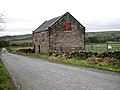 | 640 × 480 (95 KB) | GeographBot | == {{int:filedesc}} == {{Information |description={{en|1=Barn near Brund A substantial barn still in good order. Many similar barns in this area have fallen into disrepair.}} |date=2007-01-12 |source=From [http://www.geograph.org.uk/photo/310926 geograp |
The following page uses this file:
This file contains additional information, probably added from the digital camera or scanner used to create or digitize it.
If the file has been modified from its original state, some details may not fully reflect the modified file.
