Click on a date/time to view the file as it appeared at that time.
| Date/Time | Thumbnail | Dimensions | User | Comment |
|---|
| current | 17:12, 31 January 2010 | 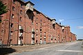 | 640 × 427 (73 KB) | GeographBot | == {{int:filedesc}} == {{Information |description={{en|1=Bass Maltings. The vast semi-derelict Grade II* listed maltings dominate the skyline approaching Sleaford from the south http://www.geograph.org.uk/photo/254319, opened in 1905 they are an impressiv |
The following pages on the English Wikipedia use this file (pages on other projects are not listed):
The following other wikis use this file:
- Usage on azb.wikipedia.org
- Usage on fa.wikipedia.org
- Usage on www.wikidata.org
This file contains additional information, probably added from the digital camera or scanner used to create or digitize it.
If the file has been modified from its original state, some details may not fully reflect the modified file.
