Loading
  • 21 Aug, 2019

  • By, Wikipedia

File:Bass Strait Infrastructure.png

العربيَّة | English | فارسی | français | עברית | македонски | മലയാളം | Nederlands | русский | 中文(中国大陆)‎ | +/−

Public domain This work has been released into the public domain by its author, Chuq at English Wikipedia. This applies worldwide.
In some countries this may not be legally possible; if so:
Chuq grants anyone the right to use this work for any purpose, without any conditions, unless such conditions are required by law.

Original upload log

The original description page was here. All following user names refer to en.wikipedia.
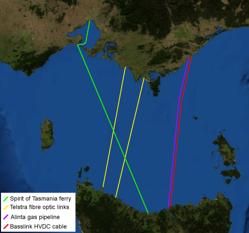
  • 2006-04-15 06:46 Chuq 500×467× (195974 bytes) Map of [[Bass Strait]] including electrical, gas, communications and transport infrastructure. Background imagery derived from [[NASA World Wind]].

Captions

Add a one-line explanation of what this file represents

Items portrayed in this file

depicts

image/png

9024966facbbe4953ebcb4623454e56a3f36a142

195,974 byte

467 pixel

500 pixel

File history

Click on a date/time to view the file as it appeared at that time.

Date/TimeThumbnailDimensionsUserComment
current12:49, 8 July 2009Thumbnail for version as of 12:49, 8 July 2009500 × 467 (191 KB)File Upload Bot (Magnus Manske) {{BotMoveToCommons|en.wikipedia|year={{subst:CURRENTYEAR}}|month={{subst:CURRENTMONTHNAME}}|day={{subst:CURRENTDAY}}}} {{Information |Description={{en|Map of en:Bass Strait including electrical, gas, communications and transport infrastructure. Ba
The following pages on the English Wikipedia use this file (pages on other projects are not listed):

Global file usage

The following other wikis use this file: