Loading
  • 21 Aug, 2019

  • By, Wikipedia

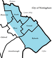
File:Beeston Wards Map.png

Transferred from en.wikipedia to Commons by Logan using CommonsHelper.

The original description page was here. All following user names refer to en.wikipedia.
  • 2010-09-07 14:01 Dpaajones 620×665× (33105 bytes) {{Information |Description = Map of wards and historic town area (light blue) of [[Beeston, Nottinghamshire]] |Source = I (~~~) created this work entirely by myself. |Date = September 2010 |Author = ~~~ |other_versions =
Captions

Add a one-line explanation of what this file represents

Items portrayed in this file

depicts

image/png

eb73186159d018d38dc71e9d25f916eb882602b0

33,105 byte

665 pixel

620 pixel

File history

Click on a date/time to view the file as it appeared at that time.

Date/TimeThumbnailDimensionsUserComment
current23:26, 13 September 2011Thumbnail for version as of 23:26, 13 September 2011620 × 665 (32 KB)File Upload Bot (Magnus Manske) {{BotMoveToCommons|en.wikipedia|year={{subst:CURRENTYEAR}}|month={{subst:CURRENTMONTHNAME}}|day={{subst:CURRENTDAY}}}} {{Information |Description={{en|Map of wards and historic town area (light blue) of en:Beeston, Nottinghamshire}} |Source=Transfe

The following page uses this file: