Click on a date/time to view the file as it appeared at that time.
| Date/Time | Thumbnail | Dimensions | User | Comment |
|---|
| current | 21:39, 3 April 2010 | 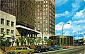 | 757 × 479 (188 KB) | Amineshaker | {{Information |Description={{en|1=Color photocrome postcard of the Downtown Berkeley BART Station and Berkeley Chamber of Commerce building. The BART sta |
The following pages on the English Wikipedia use this file (pages on other projects are not listed):
The following other wikis use this file:
- Usage on ar.wikipedia.org
- Usage on id.wikipedia.org
- Usage on www.wikidata.org
- Usage on zh.wikipedia.org
This file contains additional information, probably added from the digital camera or scanner used to create or digitize it.
If the file has been modified from its original state, some details may not fully reflect the modified file.

