Click on a date/time to view the file as it appeared at that time.
| Date/Time | Thumbnail | Dimensions | User | Comment |
|---|
| current | 07:47, 31 January 2010 | 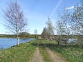 | 640 × 480 (132 KB) | GeographBot | == {{int:filedesc}} == {{Information |description={{en|1=Bridle path and nature reserve near to Kirkby on Bain.}} |date=2006-04-28 |source=From [http://www.geograph.org.uk/photo/162506 geograph.org.uk] |author=[http://www.geograph.org.uk/profile/4482 Mike |
The following pages on the English Wikipedia use this file (pages on other projects are not listed):
This file contains additional information, probably added from the digital camera or scanner used to create or digitize it.
If the file has been modified from its original state, some details may not fully reflect the modified file.
