File:British Isles.svg
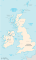
An SVG map of the British Isles, with the largest islands and archipelagos labelled.
Source
Own work
Author
Smurrayinchester
SVG development 

Always considered part of the British Isles
Sometimes considered part of the British Isles
Other lands
This W3C-invalid map was created with an unknown SVG tool.
This map is translated using SVG
switch elements: all translations are stored in the same file.}
Licensing
I, the copyright holder of this work, hereby publish it under the following license:

|
Permission is granted to copy, distribute and/or modify this document under the terms of the GNU Free Documentation License, Version 1.2 or any later version published by the Free Software Foundation; with no Invariant Sections, no Front-Cover Texts, and no Back-Cover Texts. A copy of the license is included in the section entitled GNU Free Documentation License. |
| This file is licensed under the Creative Commons Attribution-Share Alike 3.0 Unported license. | ||
| ||
| This licensing tag was added to this file as part of the GFDL licensing update. |
Derivative works
-
 македонски
 -
 Flag map (1801–1922)


derivative works
Derivative works of this file: British Isles mk.svg


