Loading
  • 21 Aug, 2019

  • By, Wikipedia

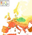
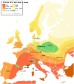
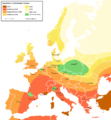
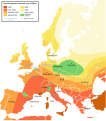
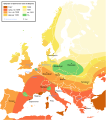
File:Bubonic Plague Map.PNG

Summary

Description
Deutsch: Beulenpest Karte – mit Englischem Text
  • Ausbreitung der Beulenpest in Europa zwischen 1347 und 1351
  • Hinweis: Die Grenzen der Karte zeigen deren heutigen Verlauf, nicht den der späten 1340er Jahre!
English: Bubonic Plague Map – with English text
  • Spreading of the Bubonic Plague in Europe between 1347 and 1351
  • Note: The borders on the map illustrate present day borders, not those of the late 1340s!
Date
Source
  • Translation of this: de-Wikipedia German map into English
  • For the de-WP-image: Atlas zur Weltgeschichte (Atlas of World History)
Author
Other versions [edit]   
Versioning
InfoField
  • Version 1.2
  • Changelog: 1.1: new map -> 1.2: enlarged, new larger city-points, text replaced with enlarged font (Linux-"Sans Bold", 18pt)
  • Changelog: 1.0: new map -> 1.1: more details, color changes, more cities

Licensing

GNU head Permission is granted to copy, distribute and/or modify this document under the terms of the GNU Free Documentation License, Version 1.2 or any later version published by the Free Software Foundation; with no Invariant Sections, no Front-Cover Texts, and no Back-Cover Texts. A copy of the license is included in the section entitled GNU Free Documentation License.
w:en:Creative Commons
attribution share alike
This file is licensed under the Creative Commons Attribution-Share Alike 3.0 Unported license.
You are free:
  • to share – to copy, distribute and transmit the work
  • to remix – to adapt the work
Under the following conditions:
  • attribution – You must give appropriate credit, provide a link to the license, and indicate if changes were made. You may do so in any reasonable manner, but not in any way that suggests the licensor endorses you or your use.
  • share alike – If you remix, transform, or build upon the material, you must distribute your contributions under the same or compatible license as the original.
This licensing tag was added to this file as part of the GFDL licensing update.

Captions

Add a one-line explanation of what this file represents

Items portrayed in this file

depicts

3 April 2005

image/png

8301816403e83bca7f212b93552b88b071d05e5f

492,326 byte

1,108 pixel

1,024 pixel

File history

Click on a date/time to view the file as it appeared at that time.

Date/TimeThumbnailDimensionsUserComment
current19:57, 8 February 2014Thumbnail for version as of 19:57, 8 February 20141,024 × 1,108 (481 KB)JaybearColor for 1347-regions darkened; title edited;
20:41, 5 February 2014Thumbnail for version as of 20:41, 5 February 20141,024 × 1,108 (479 KB)JaybearEnlarged map with new written text; (Oops: there exist's different svg-versions ... but nobody has inserted the svg-subversion-template to them on this image-page ;-( ... and the writing seems to be a little faint);
20:21, 15 May 2005Thumbnail for version as of 20:21, 15 May 2005554 × 600 (149 KB)Danny~commonswiki{{GFDL}} Translated from the German map by de:Benutzer:Roger Zenner
20:13, 15 May 2005Thumbnail for version as of 20:13, 15 May 2005554 × 600 (149 KB)Danny~commonswiki{{GFDL}} Translation of German map into English Original by de:Benutzer:Roger Zenner

Global file usage

The following other wikis use this file:

Metadata