Loading
  • 21 Aug, 2019

  • By, Wikipedia

File:CEM-44-La-Chine-la-Tartarie-Chinoise-et-le-Thibet-1734-Amur-2572.jpg

Entire map:

Two halves:

Fragments:


Public domain

This work is in the public domain in its country of origin and other countries and areas where the copyright term is the author's life plus 100 years or fewer.


You must also include a United States public domain tag to indicate why this work is in the public domain in the United States.

Annotations
InfoField
This image is annotated: View the annotations at Commons

Captions

Add a one-line explanation of what this file represents

Items portrayed in this file

depicts

image/jpeg

be3c5de3b93b58765dce33c9cf98f92df8eb8e0b

1,942,549 byte

1,872 pixel

2,492 pixel

File history

Click on a date/time to view the file as it appeared at that time.

Date/TimeThumbnailDimensionsUserComment
current01:07, 7 June 2010Thumbnail for version as of 01:07, 7 June 20102,492 × 1,872 (1.85 MB)Ras67losslessly cropped with Jpegcrop
13:32, 22 March 2009Thumbnail for version as of 13:32, 22 March 20092,560 × 1,920 (2.07 MB)Vmenkov
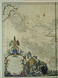
{{Information |Description={{fr|Carte la plus generale et qui comprend la Chine, la Tartarie Chinoise, et le Thibet. Dressee sur les cartes particuliers des RR PP Jesuites, par le Sr. d'Anville..., qui ya joint le pays compris entre Kashgar et la mar Casp

Global file usage

The following other wikis use this file:

View more global usage of this file.

Metadata