Loading
  • 21 Aug, 2019

  • By, Wikipedia

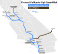
File:Cahsr Map.svg

This image is a derivative work of the following images:

  • File:Blank_California_Map.svg licensed with PD-self
    • 2007-12-24T11:37:44Z Thadius856 621x733 (515300 Bytes)
    • 2007-12-24T11:13:25Z Thadius856 708x957 (516499 Bytes) {{Information |Description=Blank map of the state of California, USA with counties shown. |Source=Self-made. ''HEAVILY'' modified manually from [[Image:California_county_map.svg|]]; style inspired by [[User:Biercenator|Frank

Uploaded with derivativeFX
Captions

Add a one-line explanation of what this file represents

Items portrayed in this file

depicts

image/svg+xml

679c69d34abb104c69e82badc51ba8a63ebc6136

407,086 byte

541 pixel

586 pixel

File history

Click on a date/time to view the file as it appeared at that time.

Date/TimeThumbnailDimensionsUserComment
current22:57, 16 April 2020Thumbnail for version as of 22:57, 16 April 2020586 × 541 (398 KB)Fluffy89502relevancy
19:30, 30 April 2009Thumbnail for version as of 19:30, 30 April 2009586 × 541 (645 KB)CountZ{{Information |Description=Map of planned high speed rail lines in California. |Source=*File:Blank_California_Map.svg |Date=2009-04-30 20:30 (UTC) |Author=*File:Blank_California_Map.svg: Thadius856 *derivative work: ~~~
The following pages on the English Wikipedia use this file (pages on other projects are not listed):

Global file usage

The following other wikis use this file:

Metadata