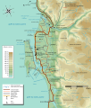
File:Carte Topographique Chéticamp.svg
Click on a date/time to view the file as it appeared at that time.
| Date/Time | Thumbnail | Dimensions | User | Comment | |
|---|---|---|---|---|---|
| current | 15:20, 13 February 2010 |  | 1,150 × 1,350 (434 KB) | Dr Wilson | corrections |
| 01:09, 9 November 2009 |  | 1,150 × 1,350 (434 KB) | Dr Wilson | Taille du texte, corrections mineures | |
| 23:28, 8 November 2009 |  | 1,150 × 1,350 (433 KB) | Dr Wilson | Ajouts et corrections | |
| 20:46, 12 August 2009 |  | 1,150 × 1,350 (415 KB) | Dr Wilson | correction de l'échelle | |
| 19:44, 12 August 2009 |  | 1,150 × 1,350 (415 KB) | Dr Wilson | Oublié l'échelle | |
| 19:38, 12 August 2009 |  | 1,150 × 1,350 (410 KB) | Dr Wilson | corrections mineures | |
| 16:37, 2 July 2009 |  | 1,150 × 1,350 (418 KB) | Dr Wilson | {{Information |Description={{en|1=A topographic map of Chéticamp, Nova Soctia.}} {{fr|1=Carte topographique de Chéticamp, en Nouvelle-Écosse.}} |Source=travail personnel (own work) |Author=Dr Wilson |Date=2 juillet 2009 |Permission= |
File usage
The following pages on the English Wikipedia use this file (pages on other projects are not listed):
Global file usage
The following other wikis use this file:
- Usage on fr.wikipedia.org