Click on a date/time to view the file as it appeared at that time.
| Date/Time | Thumbnail | Dimensions | User | Comment |
|---|
| current | 16:51, 4 January 2011 | 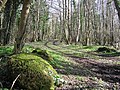 | 640 × 479 (124 KB) | GeographBot | == {{int:filedesc}} == {{Information |description={{en|1=Causeway at Inish Decarne, Lough Erne This is the connecting link between the island and the mainland.}} |date=2007-03-13 |source=From [http://www.geograph.org.uk/photo/365562 geograph.org.uk] |auth |
The following pages on the English Wikipedia use this file (pages on other projects are not listed):
This file contains additional information, probably added from the digital camera or scanner used to create or digitize it.
If the file has been modified from its original state, some details may not fully reflect the modified file.
