21 Aug, 2019
By, Wikipedia
File:Central Biscayne Bay Chart.pdf
https://creativecommons.org/publicdomain/mark/1.0/PDMCreative Commons Public Domain Mark 1.0falsefalse
Captions
Navigational chart of Central Biscayne Bay in Florida, US
Click on a date/time to view the file as it appeared at that time.
| Date/Time | Thumbnail | Dimensions | User | Comment | |
|---|---|---|---|---|---|
| current | 11:54, 1 May 2021 | 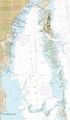 | 2,518 × 4,331 (1.25 MB) | Donald Albury | cropped from original image |
| 20:06, 29 April 2021 | No thumbnail | 0 × 0 (3.72 MB) | Donald Albury | Uploaded a work by Natioan Oceanic and Atmospheric Administration from https://www.charts.noaa.gov/PDFs/11465.pdf with UploadWizard |
The following 3 pages use this file: