File:Central Europe 1572.png
http://creativecommons.org/publicdomain/zero/1.0/deed.en CC0 Creative Commons Zero, Public Domain Dedication false false
References
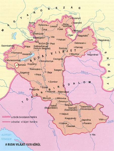
http://www.sulinet.hu/eletmod/hogyantovabb/tovabbtanulas/elokeszito/tortenelem/6het/map.jpg http://honismeret.uw.hu/pictures/history/oszman_torok_birodalom_big.jpg archive copy at the Wayback Machine http://www.kepido.oszk.hu/attachments/images/nagy/pe94122.jpg http://mek.niif.hu/01800/01885/html/cd5m/kepek/nyelvtortenet/ny251pe94122.jpg http://mek.oszk.hu/01800/01885/html/cd5m/kepek/c4341pe94122.jpg http://mek.oszk.hu/01800/01885/html/cd5m/kepek/tortenelem/to321pe94123b.jpg http://hu.wikipedia.org/key/Fájl:Torokvilag.jpg http://www.sulinet.hu/oroksegtar/data/telepulesek_ertekei/Erd/pages/images/221.jpg http://xxlworld.xx.ohost.de/povijest/slike/mape/1606.jpg http://www.hic.hr/books/pavlicev/images/s05.gif archive copy at the Wayback Machine The Times History of Europe, Times Books, London, 2002.
Peter Rokai - Zoltan Đere - Tibor Pal - Aleksandar Kasaš, Istorija Mađara, Beograd, 2002.
Dr Dušan J. Popović, Srbi u Vojvodini, knjiga 1, Novi Sad, 1990.
Dr D. J. Popović, Vojvodina u tursko doba, Zbornik "Vojvodina", knjiga I, Fototipsko izdanje, PROMETEJ, Novi Sad, 2008.
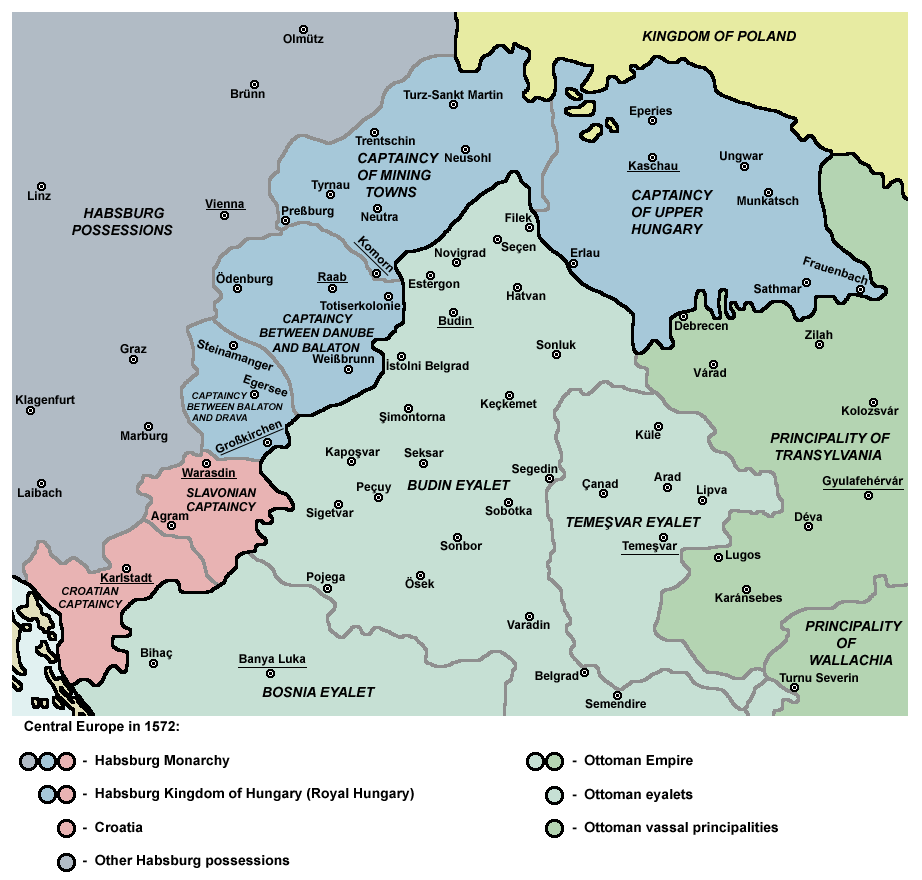
Halil Inaldžik, Osmansko carstvo, Beograd, 2003. English Map of Central Europe in 1572
Click on a date/time to view the file as it appeared at that time.
Date/Time Thumbnail Dimensions User Comment current 10:36, 5 September 2011 922 × 880 (120 KB) PANONIAN {{Information |Description ={{en|1=Map of Central Europe in 1572: Habsburg Kingdom of Hungary (Royal Hungary), Habsburg Croatia, Ottoman Budin Eyalet, Ottoman Temeşvar Eyalet. }} |Source ={{own}} |Author =PANONIAN |Da
The following other wikis use this file:
Usage on ar.wikipedia.org
Usage on be.wikipedia.org
Usage on bg.wikipedia.org
Usage on bs.wikipedia.org
Usage on cs.wikipedia.org
Usage on de.wikipedia.org
Usage on el.wikipedia.org
Usage on eo.wikipedia.org
Usage on es.wikipedia.org
Usage on et.wikipedia.org
Usage on fa.wikipedia.org
Usage on fr.wikipedia.org
Usage on he.wikipedia.org
Usage on hr.wikipedia.org
Usage on hu.wikipedia.org
Usage on it.wikipedia.org
Usage on ja.wikipedia.org
Usage on ko.wikipedia.org
Usage on ku.wikipedia.org
View more global usage of this file.